Σύστημα Ισοπέδωσης GPS AG2000

Σύστημα Ισοπέδωσης GPS AG2000
Το σύστημα AG2000-3 είναι ένα σύστημα ισοπέδωσης γης υψηλής ακρίβειας και υψηλής απόδοσης GNSS, το οποίο αναπτύχθηκε ανεξάρτητα από την SunNav.Χρησιμοποιείται ευρέως στη γεωργία ακριβείας για την αποκατάσταση ερειπίων, την αποκατάσταση και ισοπέδωση γης, τη μετατροπή γης σε πλαγιές, την ισοπέδωση ορυζώνων, την ισοπέδωση ξηρής γης και την ισοπέδωση γης άλλων μεγάλων περιοχών. Μπορεί επίσης να χρησιμοποιηθεί για τη συντήρηση των υδάτων, την κατασκευή αεροδρομίων και την κατασκευή σταδίων μεγάλης κλίμακας.
Διαφέρουμε..
Χωρίς εξωτερικές κεραίες και χωρίς καμία συνδρομή. Ακρίβεια RTK παντού και πάντοτε.
Διαθέτει ελληνικά μενού και παρέχετε απομακρυσμένος προγραμματισμός όλων των παρελκομένων. Παρέχετε δωρεάν απομακρυσμένη υποστήριξη και δωρεάν εγκατάσταση σε όλη την Ηπειρωτική Ελλάδα εκτός της Πελλοπονήοσυ που υπάρχει μία επιπλέον χρέωση.
Χαρακτηριστικά
- Οθόνη αφής 10,1 ιντσών, εύκολη λειτουργία, προβολή σε πραγματικό χρόνο της διαφοράς ύψους και των πληροφοριών για την κατάσταση του εξοπλισμού.
- Τρισδιάστατη απεικόνιση εικόνας, απεικόνιση υψηλού και χαμηλού εδάφους, σαφής με μια ματιά.
- Υποστήριξη μονής και διπλής ισοπέδωσης κλίσης.
- Υποστήριξη τοπογραφίας γης και λειτουργία ρύθμισης BENCHMARK με ένα πλήκτρο, γρήγορη και αποτελεσματική.
- Υποστήριξη σύνδεσης σταθμού βάσης και σταθμού Cors, παροχή εργασίας ισοπέδωσης γης υψηλής ακρίβειας. Η ακρίβεια ισοπέδωσης γης μπορεί να είναι ±2 cm.
- Μεγάλη απόσταση εργασίας, 3-5KM (εσωτερική ραδιοεπικοινωνία), 10-15KG (εξωτερική ραδιοεπικοινωνία), 30-50KM (σταθμός Cors).
- Ρυθμιζόμενη ακρίβεια ελέγχου, ρυθμιζόμενη ευαισθησία απόκρισης ηλεκτρομαγνητικής βαλβίδας Υποστήριξη 100M Ethernet, 4G full Netcom, WIFI, Bluetooth διεπαφή επικοινωνίας
T201 Κονσόλα
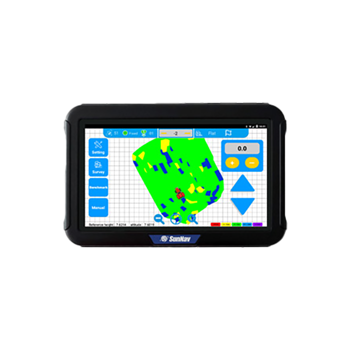
Η οθόνη SunNav T201 είναι ένα φορητό, στιβαρό tablet Android. Το T201 παρέχει επίσης RS-232/485, USB 2.0, GPIO, CAN, διεπαφή σήματος CVBS για σύνδεση με άλλους εξοπλισμούς και υποστηρίζει ασύρματη επικοινωνία WI-FI, 3G / 4G LTE.
Κουτί ελέγχου AC201
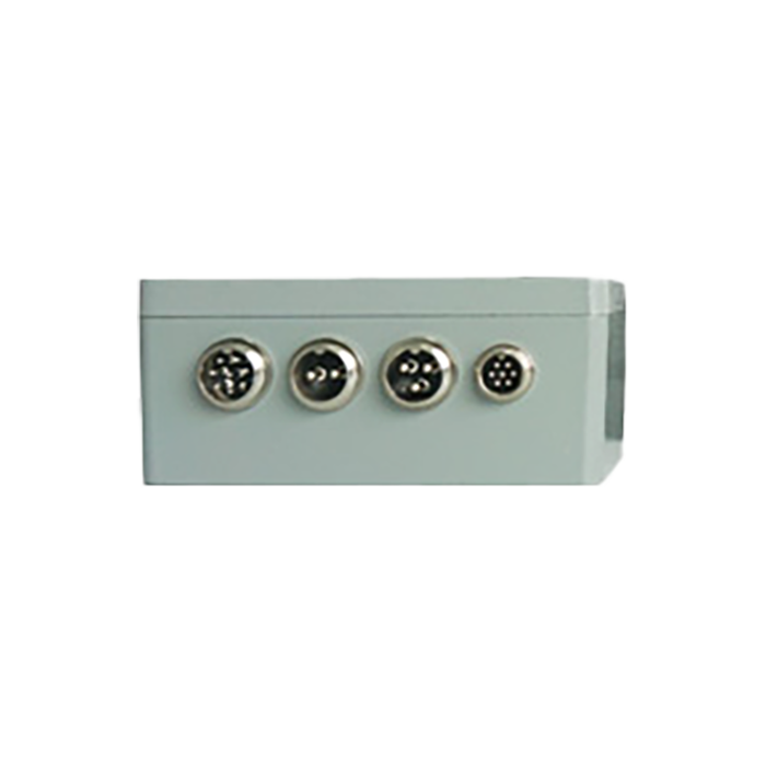
Το AC201 είναι ένα κιβώτιο ελέγχου τοποθέτησης υψηλής ακρίβειας για τον έλεγχο της λειτουργίας μηχανημάτων και εξοπλισμού.
Κεραία GNSS
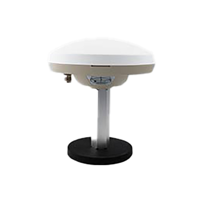
Η κεραία GNSS μπορεί να δώσει υψηλή ακρίβεια και κατεύθυνση.
Τηλεχειριστήριο
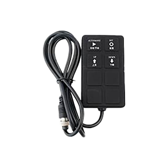
Το τηλεχειριστήριο είναι ένας χειροκίνητος ελεγκτής, αδιάβροχος και ανθεκτικός στη σκόνη είναι IP65.
604 Σχόλια
Adotto un approccio basato sui dati per valutare le mie performance su Betonred. Mostro i miei fogli di calcolo e le mie analisi per giocare in modo più scientifico.
เปลี่ยนการเสี่ยงโชคแบบเดิมๆ ให้ทันสมัยและสะดวกสบายกว่าที่เคยกับบริการหวยออนไลน์ของ thaiwebscan.com เราเปิดให้คุณแทงหวยได้ครบทุกรูปแบบ ทั้งหวยไทย หวยลาว หวยฮานอย และหวยหุ้นจากทั่วทุกมุมโลก พร้อมอัตราการจ่ายที่สูงที่สุด รับประกันว่าคุ้มค่าและตอบโจทย์คอหวยทุกกลุ่ม หมดกังวลเรื่องปัญหาเลขอั้นหรือการจ่ายเงินที่ไม่เต็มจำนวน เพราะเรามีฐานะทางการเงินที่มั่นคงและระบบที่ตรวจสอบได้ทันทีหลังประกาศผลรางวัล เงินรางวัลของคุณจะถูกโอนเข้าบัญชีอย่างรวดเร็วและแม่นยำ ให้คุณลุ้นโชคได้อย่างสบายใจและเต็มไปด้วยความตื่นเต้นในทุกงวด สถานที่:ประเทศไทย เข้าใช้งาน:https://thaiwebscan.com
Domine as apostas esportivas com a Verifique: aqui você encontra as melhores odds, estatísticas detalhadas e palpites certeiros para lucrar alto em todos os jogos do Brasileirão e das grandes ligas mundiais. https://verifique.seminariodiamantina.org.br
Descubra a identidade por trás de cada domínio com a brwhoislookup.com: nossa plataforma oferece insights profundos e dados precisos para que você valide a credibilidade de qualquer site e tome decisões seguras no mundo dos negócios digitais. https://brwhoislookup.com
ยกคาสิโนระดับโลกมาไว้ในมือคุณด้วยบริการคาสิโนสดจาก safenaming.com ที่มอบประสบการณ์การเดิมพันสุดสมจริงผ่านระบบถ่ายทอดสดความคมชัดระดับ Full HD คุณจะได้ร่วมสนุกกับดีลเลอร์มืออาชีพที่คอยให้บริการอย่างใกล้ชิด สร้างบรรยากาศที่ตื่นเต้นและหรูหราเสมือนนั่งเดิมพันอยู่ในคาสิโนสถานที่จริง ระบบของเรามีความโปร่งใสและยุติธรรมสูงสุด การเดิมพันทุกขั้นตอนสามารถตรวจสอบได้ มอบความมั่นใจให้กับผู้เล่นทุกคนด้วยแพลตฟอร์มที่เสถียรและรวดเร็ว ไม่ว่าคุณจะชื่นชอบเกมคาสิโนประเภทไหน ที่นี่คือคำตอบที่ดีที่สุดสำหรับคนที่มองหาความสนุกระดับพรีเมียม สถานที่:ประเทศไทย เข้าใช้งาน:https://safenaming.com/
Transforme a `brasildomain.com` na sua base operacional de elite: centralize o gerenciamento de seus ativos digitais, monitore o ciclo de vida dos seus domínios e garanta que sua presença online no Brasil tenha a autoridade necessária para superar a concorrência. https://brasildomain.com
ร้านค้าส่งกระจกโฟลต กระจกนิรภัย อลูมิเนียมเส้น แผ่นฝ้าและอุปกรณ์ติดตั้งฝ้า แผ่นยิปซั่มและอุปกรณ์ติดตั้งผนังเบา ประตูหน้าต่างไวนิล รายใหญ่ของปทุมธานี มาที่เดียวได้ครบ มีที่จอดรถหน้าร้านเหลือเฟือ https://cityglassrangsit.thlocalweb.com
Alcance uma gestão de domínios em nível global com a `internamepro.com`: nossa plataforma oferece ferramentas de monitoramento de alta performance e consultoria estratégica para você proteger seus ativos digitais e escalar sua presença internacional com total autoridade e segurança. https://internamepro.com
อินดัสเทรียล ฟู้ด ซัพพลาย (INDUSTRIAL FOODS SUPPLY CO.,LTD.) รับผลิตท้อปปิ้ง น้ำเชื่อม ซอสช็อคโกแลต ซอสผลไม้ สำหรับเคลือบไอศกรีม ซอสราดเค้ก ไซรัปผสมเครื่องดื่มค็อกเทล บิงซู และสำหรับใช้ในโรงงานอุตสาหกรรมการผลิตขนม ของหวาน ไอศครีม คาเฟ่ และบาร์ เพื่อช่วยเพิ่มรสชาติที่ยอดเยี่ยม หน้าตาสีสันที่สวยงามน่ารับประทาน ทางบริษัทมีทีมงานวิจัยผลิตภัณฑ์ตลอดจนคิดค้นผลิตภัณฑ์ให้ได้ตรงตามความต้องการของลูกค้าสำหรับใช้เป็นส่วนผสมที่ดีที่สุด https://industrialfoodssupply.thlocalweb.com
สำหรับนักเดิมพันที่หลงใหลในความแม่นยำและกลยุทธ์ บาคาร่าที่ thaiviaweb คือตัวเลือกอันดับหนึ่งที่เซียนพนันไว้วางใจ ด้วยระบบเค้าไพ่ที่ดูง่าย อัปเดตแบบเรียลไทม์ และอัตราการจ่ายที่คุ้มค่าที่สุดในตลาด ทำให้คุณสามารถวางแผนการเดินเงินได้อย่างมั่นใจในทุกรอบการเดิมพัน เราให้ความสำคัญกับประสบการณ์ของผู้เล่นเป็นหลัก ระบบของเราจึงมีความรวดเร็วและรองรับการใช้งานที่เสถียร ไม่ว่าคุณจะเป็นมือใหม่ที่เพิ่งเริ่มต้นหรือนักเดิมพันระดับมือโปร คุณจะเพลิดเพลินไปกับเกมบาคาร่าที่สนุก ตื่นเต้น และเห็นผลกำไรได้อย่างชัดเจนและเป็นธรรม สถานที่: ประเทศไทย เข้าใช้งาน: https://thaiviaweb.com
สัมผัสประสบการณ์ความสนุกเหนือระดับกับอาณาจักรสล็อตออนไลน์ที่ checkthai เราคัดสรรเกมสล็อตคุณภาพจากค่ายดังทั่วโลกมาไว้ให้คุณเลือกเล่นมากกว่าพันรายการ ด้วยกราฟิกที่สวยงามตระการตาและฟีเจอร์โบนัสที่แตกง่ายที่สุด ทำให้ทุกการหมุนของคุณเต็มไปด้วยโอกาสในการลุ้นรางวัลใหญ่ที่อาจเปลี่ยนชีวิตคุณได้ในพริบตา ไม่ว่าจะเป็นสล็อตวิดีโอธีมใหม่ล่าสุดหรือเกมสล็อตคลาสสิกยอดนิยม ระบบของเราถูกออกแบบมาให้ลื่นไหล ไม่มีสะดุด รองรับการเล่นทุกแพลตฟอร์ม ไม่ว่าจะเป็นคอมพิวเตอร์หรือสมาร์ทโฟน คุณก็สามารถสนุกกับแจ็คพอตแตกกระจายได้ทุกที่ทุกเวลาตลอด 24 ชั่วโมง สถานที่: ประเทศไทย เข้าใช้งาน:https://checkthai.com
Garanta total transparência e inteligência competitiva com a `whoisbrasil.com`: utilize nosso sistema de varredura profunda para validar a reputação de parceiros, investigar a origem de domínios e fortalecer sua estratégia de marca com dados precisos sobre o mercado brasileiro. https://whoisbrasil.com
Eleve o nível da sua segurança digital com a `brwhoispro.com`: nossa solução oferece uma camada de análise avançada e rastreamento de infraestrutura, permitindo que você audite registros com precisão profissional e proteja seus ativos contra riscos de mercado. https://brwhoispro.com
สำหรับเจ้าของเว็บไซต์ที่มองหาการเข้ารหัสข้อมูลและความน่าเชื่อถือที่เหนือกว่า Security-SSL คือทางเลือกที่ใช่ที่สุดในตลาด ด้วยใบรับรอง SSL หลากหลายประเภทที่เหมาะกับทุกขนาดธุรกิจ ออกใบรับรองรวดเร็วภายในไม่กี่นาที ราคาคุ้มค่า และการันตีความเข้ากันได้กับทุกเบราว์เซอร์ ทำให้คุณปกป้องข้อมูลลูกค้าและเพิ่มอันดับเว็บไซต์บน Google ได้อย่างมืออาชีพ เราให้ความสำคัญกับประสบการณ์ของผู้ใช้งานเป็นหลัก ระบบของเราจึงง่ายต่อการติดตั้งและต่ออายุอัตโนมัติ พร้อมทีมสนับสนุนที่คอยช่วยเหลือคุณตลอด 24 ชั่วโมง ไม่ว่าคุณจะเป็นมือใหม่ที่พึ่งทำเว็บไซต์ครั้งแรก หรือบริษัทที่ต้องการระบบความปลอดภัยระดับองค์กร คุณจะวางใจได้ในความเสถียรและความเป็นธรรมของเรา สถานที่: ให้บริการทั่วโลก เข้าใช้งาน: https://security-ssl.com
สำหรับผู้ดูแลเว็บไซต์ที่ให้ความสำคัญกับความปลอดภัยและความเชื่อมั่นของลูกค้า TrustScan คือเครื่องมือสแกนเว็บอันดับหนึ่งที่ผู้เชี่ยวชาญด้านไอทีไว้วางใจ ด้วยระบบตรวจจับมัลแวร์และช่องโหว่ที่แม่นยำ อัปเดตฐานข้อมูลภัยคุกคามแบบเรียลไทม์ และรายงานที่เข้าใจง่าย ทำให้คุณสามารถดูแลเว็บไซต์ของคุณได้อย่างมั่นใจตลอดเวลา ระบบของเราถูกออกแบบมาให้ใช้งานได้รวดเร็ว เสถียร และรองรับทั้งเว็บไซต์ขนาดเล็กไปจนถึงองค์กรขนาดใหญ่ ไม่ว่าคุณจะเป็นมือใหม่ที่เพิ่งเริ่มทำเว็บ หรือผู้ดูแลระบบมืออาชีพ คุณจะได้รับประสบการณ์การตรวจสอบที่ครบถ้วน ปลอดภัย และเห็นผลลัพธ์ที่ชัดเจน สถานที่: บราซิล (ให้บริการทั่วโลก) เข้าใช้งาน: https://trustscan.arquidiocesedecuritiba.org.br
สัมผัสประสบการณ์ความสนุกเหนือระดับกับอาณาจักรสล็อตออนไลน์ที่ checkthai เราคัดสรรเกมสล็อตคุณภาพจากค่ายดังทั่วโลกมาไว้ให้คุณเลือกเล่นมากกว่าพันรายการ ด้วยกราฟิกที่สวยงามตระการตาและฟีเจอร์โบนัสที่แตกง่ายที่สุด ทำให้ทุกการหมุนของคุณเต็มไปด้วยโอกาสในการลุ้นรางวัลใหญ่ที่อาจเปลี่ยนชีวิตคุณได้ในพริบตา ไม่ว่าจะเป็นสล็อตวิดีโอธีมใหม่ล่าสุดหรือเกมสล็อตคลาสสิกยอดนิยม ระบบของเราถูกออกแบบมาให้ลื่นไหล ไม่มีสะดุด รองรับการเล่นทุกแพลตฟอร์ม ไม่ว่าจะเป็นคอมพิวเตอร์หรือสมาร์ทโฟน คุณก็สามารถสนุกกับแจ็คพอตแตกกระจายได้ทุกที่ทุกเวลาตลอด 24 ชั่วโมง สถานที่: ประเทศไทย เข้าใช้งาน:https://checkthai.com
สำหรับผู้ดูแลเว็บไซต์ที่ให้ความสำคัญกับความปลอดภัยและความเชื่อมั่นของลูกค้า TrustScan คือเครื่องมือสแกนเว็บอันดับหนึ่งที่ผู้เชี่ยวชาญด้านไอทีไว้วางใจ ด้วยระบบตรวจจับมัลแวร์และช่องโหว่ที่แม่นยำ อัปเดตฐานข้อมูลภัยคุกคามแบบเรียลไทม์ และรายงานที่เข้าใจง่าย ทำให้คุณสามารถดูแลเว็บไซต์ของคุณได้อย่างมั่นใจตลอดเวลา ระบบของเราถูกออกแบบมาให้ใช้งานได้รวดเร็ว เสถียร และรองรับทั้งเว็บไซต์ขนาดเล็กไปจนถึงองค์กรขนาดใหญ่ ไม่ว่าคุณจะเป็นมือใหม่ที่เพิ่งเริ่มทำเว็บ หรือผู้ดูแลระบบมืออาชีพ คุณจะได้รับประสบการณ์การตรวจสอบที่ครบถ้วน ปลอดภัย และเห็นผลลัพธ์ที่ชัดเจน สถานที่: บราซิล (ให้บริการทั่วโลก) เข้าใช้งาน: https://trustscan.arquidiocesedecuritiba.org.br
สำหรับนักเดิมพันที่หลงใหลในความแม่นยำและกลยุทธ์ บาคาร่าที่ thaiviaweb คือตัวเลือกอันดับหนึ่งที่เซียนพนันไว้วางใจ ด้วยระบบเค้าไพ่ที่ดูง่าย อัปเดตแบบเรียลไทม์ และอัตราการจ่ายที่คุ้มค่าที่สุดในตลาด ทำให้คุณสามารถวางแผนการเดินเงินได้อย่างมั่นใจในทุกรอบการเดิมพัน เราให้ความสำคัญกับประสบการณ์ของผู้เล่นเป็นหลัก ระบบของเราจึงมีความรวดเร็วและรองรับการใช้งานที่เสถียร ไม่ว่าคุณจะเป็นมือใหม่ที่เพิ่งเริ่มต้นหรือนักเดิมพันระดับมือโปร คุณจะเพลิดเพลินไปกับเกมบาคาร่าที่สนุก ตื่นเต้น และเห็นผลกำไรได้อย่างชัดเจนและเป็นธรรม สถานที่: ประเทศไทย เข้าใช้งาน: https://thaiviaweb.com
สำหรับเจ้าของเว็บไซต์ที่มองหาการเข้ารหัสข้อมูลและความน่าเชื่อถือที่เหนือกว่า Security-SSL คือทางเลือกที่ใช่ที่สุดในตลาด ด้วยใบรับรอง SSL หลากหลายประเภทที่เหมาะกับทุกขนาดธุรกิจ ออกใบรับรองรวดเร็วภายในไม่กี่นาที ราคาคุ้มค่า และการันตีความเข้ากันได้กับทุกเบราว์เซอร์ ทำให้คุณปกป้องข้อมูลลูกค้าและเพิ่มอันดับเว็บไซต์บน Google ได้อย่างมืออาชีพ เราให้ความสำคัญกับประสบการณ์ของผู้ใช้งานเป็นหลัก ระบบของเราจึงง่ายต่อการติดตั้งและต่ออายุอัตโนมัติ พร้อมทีมสนับสนุนที่คอยช่วยเหลือคุณตลอด 24 ชั่วโมง ไม่ว่าคุณจะเป็นมือใหม่ที่พึ่งทำเว็บไซต์ครั้งแรก หรือบริษัทที่ต้องการระบบความปลอดภัยระดับองค์กร คุณจะวางใจได้ในความเสถียรและความเป็นธรรมของเรา สถานที่: ให้บริการทั่วโลก เข้าใช้งาน: https://security-ssl.com
Arquidiocese em destaque Geral Arquidiocese Paróquias Mundo Brasil Pastorais, Grupos e Movimentos 14 janeiro 2025 14 janeiro 2025 7 janeiro 2025 7 janeiro 2 https://web.arquiconquista.org.br
ยกคาสิโนระดับโลกมาไว้ในมือคุณด้วยบริการคาสิโนสดจาก safenaming.com ที่มอบประสบการณ์การเดิมพันสุดสมจริงผ่านระบบถ่ายทอดสดความคมชัดระดับ Full HD คุณจะได้ร่วมสนุกกับดีลเลอร์มืออาชีพที่คอยให้บริการอย่างใกล้ชิด สร้างบรรยากาศที่ตื่นเต้นและหรูหราเสมือนนั่งเดิมพันอยู่ในคาสิโนสถานที่จริง ระบบของเรามีความโปร่งใสและยุติธรรมสูงสุด การเดิมพันทุกขั้นตอนสามารถตรวจสอบได้ มอบความมั่นใจให้กับผู้เล่นทุกคนด้วยแพลตฟอร์มที่เสถียรและรวดเร็ว ไม่ว่าคุณจะชื่นชอบเกมคาสิโนประเภทไหน ที่นี่คือคำตอบที่ดีที่สุดสำหรับคนที่มองหาความสนุกระดับพรีเมียม สถานที่:ประเทศไทย เข้าใช้งาน:https://safenaming.com/
เปลี่ยนการเสี่ยงโชคแบบเดิมๆ ให้ทันสมัยและสะดวกสบายกว่าที่เคยกับบริการหวยออนไลน์ของ thaiwebscan.com เราเปิดให้คุณแทงหวยได้ครบทุกรูปแบบ ทั้งหวยไทย หวยลาว หวยฮานอย และหวยหุ้นจากทั่วทุกมุมโลก พร้อมอัตราการจ่ายที่สูงที่สุด รับประกันว่าคุ้มค่าและตอบโจทย์คอหวยทุกกลุ่ม หมดกังวลเรื่องปัญหาเลขอั้นหรือการจ่ายเงินที่ไม่เต็มจำนวน เพราะเรามีฐานะทางการเงินที่มั่นคงและระบบที่ตรวจสอบได้ทันทีหลังประกาศผลรางวัล เงินรางวัลของคุณจะถูกโอนเข้าบัญชีอย่างรวดเร็วและแม่นยำ ให้คุณลุ้นโชคได้อย่างสบายใจและเต็มไปด้วยความตื่นเต้นในทุกงวด สถานที่:ประเทศไทย เข้าใช้งาน:https://thaiwebscan.com
Hi! I just would like to offer you a big thumbs up for the excellent info you have got here on this post. I am coming back to your site for more soon.
I am extremely impressed with your writing skills and also with the layout on your weblog. Is this a paid theme or did you customize it yourself? Anyway keep up the nice quality writing, it's rare to see a nice blog like this one these days.
Creo tutorial passo-passo e guide visive per semplificare ogni aspetto di Betonred. Perfino le procedure più complesse diventeranno un gioco da ragazzi.
https://agenxia.it/it/casino/betonred/
https://www.altopianodelsole.it/casino/betonred/
https://amicireggiavenariareale.com/casino/betonred/
https://www.assist-informatique.fr/casino/betonred/
https://www.atelierdelvapore.com/casino/betonred/
https://atuttavita.com/casino/betonred
https://www.bed-in-napoli.it/casino/betonred/
https://www.besthotelsinitaly.com/casino/betonred/
https://branddiretto.com/casino/betonred/
http://campingeuropa.org/casino/betonred/
https://www.dariodomenici.it/casino/betonred/
https://www.emanuelavenanzoni.it/casino/betonred/
http://www.fisioterapiaemozionale.it/casino/betonred/
https://www.fondazionecarisap.it/casino/betonred/
http://giannioliva.it/casino/betonred/
https://goldfish.it/casino/betonred/
https://www.greenpumps.it/casino/betonred/
https://gypsophila.it/casino/betonred/
https://www.hotels-napoli.it/casino/betonred
https://miglianicotour.it/casino/betonred/
https://www.parrocchiadimaroggia.ch/casino/betonred/
https://pharmacare.srl/casino/betonred
https://www.piccolohoteltanamalia.it/casino/betonred/
https://www.spaziolegalita.it/casino/betonred/
https://www.sportcenterparma.it/casino/betonred/
https://www.ventonuovo.eu/casino/betonred/
https://witoor.com/casino/betonred/
Je combine ma passion pour la tech et les jeux d'argent. Mon blog est l'endroit où ces deux mondes se rencontrent pour analyser l'avenir du iGaming.
Met uitgebreide ervaring in de branche geef ik je een exclusief kijkje achter de coulissen. Ik deel kennis die je nergens vindt.
Il vincispin è il mio lavoro, non un banale divertimento. La mia professionalità è la migliore garanzia di eccellenza per i miei lettori.
Ik deel mijn geheimen voor effectief bankroll management. Leer hoe je je kapitaal beheert om langer te kunnen spelen en je winsten te beveiligen.
Great information. Lucky me I came across your website by chance (stumbleupon). I've bookmarked it for later!
私は、オンラインカジノ「テッドベット」のヘビーユーザーとして日々研究しています。私の記事を通して、初心者向けの始め方を紹介することに情熱を注いでいます。私の目的は、読者の皆様がテッドベットで安心して楽しめるための手助けをすることです
Je suis convaincu que le jeu doit demeurer un plaisir et une source d'amusement. C'est pourquoi je mets toujours l'accent sur les pratiques de jeu sûr et maîtrisé.
Bienvenue sur mon royaume dédié au Golden Panda Casino. Ensemble, nous allons examiner chaque avantage pour en extraire le plein potentiel.
https://projects.om-office.de/michealcurran/6869973/-/issues/1
http://47.108.192.163:3000/staciafielding
http://git.maiwd.cn:3000/monicabeaver4
https://devkona.net/sylviaabrahams
http://gitlab.itechnolabs.tech/karmastrouse2
https://michigancountryrealestate.com/agents/randycoleman86/
https://git.jaronnie.com/huldagrout309/hulda1996/wiki/Golden-Panda-Casino:-A-Deep-Dive-into-a-Fictional-Gaming-Paradise
https://dwellstone.in/author/nevaebersbach/
https://viditunes.com/@adam18z585171?page=about
https://skinforum.co.in/employer/golden-panda-casino-fr/
Of je nu een complete nieuweling bent of een doorgewinterde speler, mijn artikelen is gemaakt om elk niveau te inspireren. Met elkaar maken we een slimmere community van spelers.
Plongez avec moi dans l'le monde fascinant du Golden Panda Casino. Je serai votre sherpa dans cette quête aux jackpots.
https://hemoncjobs.com/employer/golden-panda-casino-fr/
https://www.videon.app/@angeline165873?page=about
https://centralscotlandlettings.co.uk/author/otiliaemanuel/
https://landminder.com/author/dpoted36202032
http://ems.iclematis.com:30000/benjaminshumat/2003581/wiki/Golden-Panda-Casino%3A-A-Deep-Dive-into-its-Rise%2C-Fall%2C-and-Uncertain-Future
https://logisticconsultant.net/anbieter/golden-panda-casino-fr/
http://120.78.122.153:10080/jacoblemay956
http://www.shqkxh.org:3000/johannawaltman/5091123/wiki/Golden-Panda-Casino:-A-Deep-Dive-into-Its-History%2C-Offerings%2C-and-Future
https://sonygeography.com/@latanyai470697?page=about
https://bytevidpixel.com/darylhoppe8848
Ik ben niet alleen een schrijver, maar bovenal een actieve speler die midden in de het spel staat. Mijn adviezen komen rechtstreeks uit de praktijk.
Met uitgebreide ervaring gids ik je door het digitale gokdomein. Ik ben hier om de meest effectieve tactieken en hoogste winsten te vinden.
Ik bestudeer niet alleen de spellen, maar ook de softwareproviders erachter. Begrijp welke bedrijven de beste games ontwikkelen.
https://www.astrology-network.com/blog/moon-sign-vs-sun-sign-key-differences-explained
https://www.astrology-network.com/blog/how-to-use-a-moon-sign-calculator
https://www.astrology-network.com/blog/what-does-your-moon-sign-mean
https://www.astrology-network.com/blog
https://www.astrology-network.com/moon-sign-calculator
https://www.astrology-network.com/
Ik test agressieve en veilige gokstrategieën en rapporteer de gevolgen eerlijk. Kies de methode die het beste bij je risicoprofiel past.
Ik gids je door het landschap van online casino's om de verborgen parels te spotten. Met mijn analyses vergroot je meteen je speelervaring.
Mijn ervaring in gegevensverwerking verschaft mij een bijzonder invalshoek op casinospellen. Ik pas toe cijfers om jouw aanpak te verfijnen.
Van de glitter van Vegas tot je persoonlijke woonkamer, ik neem de casino-ervaring naar jou. Maak je klaar voor exclusieve tips en anekdotes.
Mijn belevenissen zijn over de hoogtepunten en dieptepunten van een gepassioneerd gokkersleven. Eerlijkheid staat daarbij centraal.
Ik ben ervan overtuigd dat verantwoord spelen de basis is tot duurzaam plezier. Op mijn blog koppel ik winnende tactieken met onmisbare tips voor veilig gokken.
Ik ben mijn leven toegewijd aan het optimaliseren van de kunst van het gokken. Laat mij je tonen wat ik heb uitgevonden op mijn intense reis.
De software achter een online gokkast is zeker zo interessant als het spel zelf. Ik geef je een blik in de het universum van game-ontwikkelaars.
Ik onderzoek de platforms achter de online casino's. Een naadloze spelervaring en eerlijke software zijn voor mij volledig doorslaggevend.
I got boundaries wrong for years, and fully expect to be honing this essential leadership practice for the rest of my days.
What helped me most in the beginning was to remember what a boundary IS NOT, and I wonder if it might help you too:
A boundary is not a demand of someone else.
A boundary is not an idle threat.
A boundary is not an ultimatum.
A boundary is not what you’d like someone else to do or say or be.
And this last one’s for you recovering people-pleasers out there:
A boundary is not the same as learning to be more truthful about what you do and don’t want to do. I have a lot of clients who think they need to be setting more boundaries, when really, they need to stop saying “Yes” when what they mean is “No.”
What Exactly is a YouTube to MP3 Converter?
Mp3zap YouTube to MP3 converter is an online tool that allows users to extract youtube’s url convert to audios and videos shape and download it in MP3 format and MP4 format. Mostly people prefer audio versions of videos because they want to listen on the go and save space on electronic devices or build a music collection. Our youtube to mp3 converter or youtube to mp4 converter is designed to meet these needs by giving a simple way to convert youtube’s URL into audio and video format without requiring advanced skills.
Mp3zap works as a simple yt to mp3 tool that lets you turn YouTube links into portable audio files quickly. Mp3zap youtube to mp3 and mp4 converter can work in different forms. Our YouTube to MP3 Converter only needs the video URL. Just copy the link from YouTube, paste it into our tool, and click the convert button. Your file will be ready in MP3 format, and if you prefer, you can also choose MP4. You can download it to a computer or phone. Whether you want music, lectures, or podcasts, these converters make it possible to access YouTube audio and videos files offline.
Users often look for youtube to mp3 converter free options because they don’t want to pay for subscriptions. Mp3zap gives you a completely youtube to mp3converter free platform with no sign-in and no subscription required. Just paste the YouTube URL, and the file will download directly to your device. Our free converter toolare widely available and easy to use, but people also check if the youtube to mp3 converter safe to ensure their device is not at risk.
Mon ton est direct, tout comme mon amour pour le Golden Panda Casino. Ici, pas de bla-bla, que du pratique.
https://alesser.altervista.org/agente/christianelyst/
https://scm.fornaxian.tech/rodknudson5084
https://academicbard.com/employer/golden-panda-casino-fr/
https://git.voxtor.ir/aracelisweaver
http://git.365zuoye.com/lashawndaroby9
http://118.25.58.110:10880/vivienherlitz
https://g.fzfengzhi.cn/heleniredale27
https://laviniapropertieslanka.com/author/diannagetz938/
https://bricksquare.org/agent/maximobrady29/
http://139.224.196.148:3000/pxqdavida71329
Ik richt me op het doorprikken van fabels die de casinowereld plagen. Bereid je voor op eerlijke waarheden en bewezen feiten.
Als onafhankelijke content creator bied ik steevast een eerlijk oordeel. Mijn trouw ligt bij jou, de lezer.
Mijn manier van schrijven is no-nonsense, zonder valse beloftes. Ik presenteer je de naakte waarheid over winnen en verliezen.
Ik jaag niet alleen naar winst, maar ook naar de perfecte speelervaring. Ik evalueer casino's op hun algehele uitstraling en klantenservice.
Ik vertrouw dat verantwoord spelen de basis is tot blijvend plezier. Op mijn blog combineer ik winnende tactieken met onmisbare tips voor verantwoord gokken.
Mijn pen is mijn wapen om de vaak complexe casinowereld transparant te maken. Ik decodeer ingewikkelde concepten naar simpele adviezen.
I enjoy what you guys are usually up too. This kind of clever work and exposure! Keep up the fantastic works guys I've incorporated you guys to my blogroll.
I am sure this piece of writing has touched all the internet visitors, its really really nice paragraph on building up new blog.
Hi! I understand this is sort of off-topic however I had to ask. Does managing a well-established website such as yours require a lot of work? I am brand new to writing a blog but I do write in my journal daily. I'd like to start a blog so I can share my experience and thoughts online. Please let me know if you have any kind of ideas or tips for new aspiring bloggers. Thankyou!
Het ontmaskeren van onwaarheden over gokken is een van mijn geliefde bezigheden. Ik fundament mijn inzichten op feiten en cijfers, niet op mythes.
I simply couldn't leave your web site prior to suggesting that I actually enjoyed the usual information an individual supply to your guests? Is going to be again often in order to investigate cross-check new posts
I will immediately take hold of your rss as I can not find your e-mail subscription hyperlink or newsletter service. Do you have any? Kindly permit me recognise so that I could subscribe. Thanks.
ankaranın en güzel escort bayanlarının site adresi
As being a first timer, I'm exploring online for articles which can be of assistance to me. Yours is beneficial pleased to have discovered it. Thanks.
Cette plateforme est la bible pour tout amateur de Winoui Casino. Sont rassemblés ici l'intégralité de ce que vous devez savoir.
https://ssbalkitkk.com.tr/employer/winoui-777/
https://git.881221.xyz/mahaliamoon03/8159922/wiki/Five-Ways-You-may-Reinvent-WinOui-Acc%C3%A8s-S%C3%A9curis%C3%A9-With-out-Trying-Like-An-Newbie
https://jassbrar.ca/agent/celeste530099/
https://www.horizonsrealtycr.com/author/leonorakuefer9/
http://85.214.41.219:49153/benjamincastle
https://git.thinhha.pro/nildatrudel023
https://www.quality-lab.net/employer/winoui-777
https://jobs.foodtechconnect.com/companies/winoui-777/
https://gitea.mpc-web.jp/carmelabalser4/7794372/wiki/8-Extremely-Helpful-WinOui-Espace-Membre-Suggestions-For-Small-Companies
https://carrefourtalents.com/employeur/winoui-777/
What a information of un-ambiguity and preserveness of valuable know-how on the topic of unexpected feelings.
I’ll immediately seize your rss feed as I can’t find your email subscription link or newsletter service. Do you have any? Please let me recognise in order that I may just subscribe. Thanks.
Ahaa, its nice discussion about this article at this place at this blog, I have read all that, so now me also commenting here.
I’ll immdiately eize your rsss feed aas Ican’t in findig your e-mail ubscription lknk orr newqsletter service. Do you’ve any? Kindly allow mme recognize sso that I mayy subscribe. Thanks.
http://powerhousepilates.com/
https://jobzgig.com/
https://mp3zap.com/
https://mp3zap.com/
https://techlynex.com/
https://jobzgig.com/
http://powerhousepilates.com/
I sincerely think that a well-informed player is a more successful one. My blog is an knowledge base for all things casino. My chief purpose is to provide you with clear, concise, and accurate information. I create detailed guides on how to play every major casino game, from the basics of blackjack to the complexities of Pai Gow Poker. I elucidate confusing terminology and simplify complex betting strategies into easy-to-understand steps. I make it my mission being a reliable source in an industry often filled with hype. Whether you're a complete newcomer or a seasoned player looking to learn a new game, my content is designed to be your go-to reference. Knowledge is power, especially on the casino floor.
https://www.homeandhelp.co/agentes/cierrapog77258/
https://squareacre.in/agents/cecilecastrejo/
http://www.we-class.kr/vlovenus928770
https://www.nenboy.com:29283/kaceyclogstoun/online-slots-betfair2001/wiki/Dirty-Facts-About-Betfair-App-Review-Revealed
http://video.firstkick.live/read-blog/34157_betonred-casino-on-the-go-a-deep-dive-into-mobile-compatibility.html
http://git.zjsciot.com:3000/kenstreeter045
http://fzhaitaiinc.com:56702/treyalbarran8
https://flirtivo.online/@caralafountain
https://thailandproperty.com/author/louiesalerno6/
http://loyaltycoin.nl/tillybzf50519
I'm a maverick in the casino world. My approach is to question everything and bet against the crowd. This blog is for the independent thinker who isn't afraid to go against the grain. I explore popular strategies and then explain why they often fail. I champion unconventional and often overlooked betting opportunities. My style is about finding value where no one else is looking. I assert that the biggest edges are found by zigging when everyone else zags. I question the so-called "experts" and their cookie-cutter advice. I am the voice of the betting underdog. If you're tired of following the herd, you've come to the right place.
http://gitlab.solr.com.cn:10000/jensmeares0755
https://git.xun-nuo.com/luigibalderas
https://git.toot.pt/deannalandseer
http://47.98.226.240:3000/rodrickvmm742
https://gitea.4gunn.cn:52443/julissapie3611
http://gitlab.hy-bang.com:8091/laurenehamby26
https://isabelzarate.com/darwinpalumbo
https://sengit.us/margaritacadma
https://woowsent.com/read-blog/3602_we-wanted-to-draw-attention-to-corals-online-betting-so-did-you.html
https://www.cloud.file.futurestack.cn/janiceparentea/valutazioni-utenti2024/wiki/Some+Info+About+Slot+Da+Casin%25C3%25B2+That+may+Make+You+are+feeling+Higher
My existence is focused on a single concept: opportunity. I'm a professional opportunity seeker, and the betting house is my office. I do not depend on chance; I rely on mathematical certainty. This site is a straight-to-the-point window into the life of a full-time bettor. I share the unglamorous aspects of the grind, the critical nature of iron-clad bankroll management, and the advanced strategies I utilize to secure a positive return. This is not for the weekend punter. It is a serious analysis of the methods for view wagering as a vocation. When you are prepared to move beyond fun and into serious play, then you've discovered the right place.
https://rentoobuy.in/author/christoperpren/
https://git.unicom.studio/naomicrouch773
https://ophiuchus.wiki/loviegeorg526
https://www.travelmapsgo.com/marina21y42320
https://git.svidoso.com/friedacolosimo
https://qdate.ru/@rosellasmyth8
http://bbsfileserv.dyndns.org:10081/florenceq83892/5474267/issues/1
https://napvibe.com/read-blog/44779_instant-casino-a-revolution-in-gaming-or-a-house-of-cards.html
https://git.raiseyourjuice.com/jamisontidwell
https://nonoclick.com/read-blog/46779_opcoes-bancarias-no-1bet4win.html
As I see it, the most overlooked aspect of casino gaming is the social one. I'm a creator who celebrates the communal and social side of the casino. This site is about the fun of playing with friends, the camaraderie at the craps table, and the etiquette that makes the games enjoyable for everyone. I provide tips on how to be a good tablemate and how to organize fun casino outings with groups. We shall investigate games that are best enjoyed socially. My objective is to teach everyone that gambling can be a fantastic shared experience. I feel that the connections we make at the table can be as valuable as any chips we win. Let's make some fun together.
https://git.cyborggrizzly.com/deonfriend619
https://lab.chocomart.kz/artcowlishaw8/art1995/issues/1
http://osztromok.com:3164/martarodway25/marta2006/wiki/The-last-word-Secret-Of-Book-Of-Ra-Scarica
http://150.230.249.102/hazelgoderich
https://forge.amy.mov/louellalittlef
https://git.qdhtt.cn/martinakemble
https://allanstaffingagency.com/employer/astronaut-crash-game-777/
https://gitea.cncfstack.com/roxannaconn859
https://turism.travel/agent/arnoldbeazley/
https://gitea.wangyige.cn/cathytall93540/betonred-automaty1986/wiki/Betonred+No+Deposit+Bonus%3A+Unlocking+10+Euros+for+New+Players+-+A+Comprehensive+Guide.-
My strong suit is in identifying patterns and trends within the casino industry. I allow you to stay ahead of the curve.
http://yun.pashanhoo.com:9090/clytyrone83847
http://git.konsulterna.nu:3000/mauratraylor2
http://huwhois.cn:3000/morganmoncrief
https://jobs.assist24-7.com/employer/cassino-bones/
http://223.68.171.150:8004/brendaadam2075
https://gitlab.ngser.com/julienneseyler
https://remotejobscape.com/companies/duelz-casino-365/
https://play.metalsunny.net/@hermelinda6881?page=about
http://119.96.213.127:9006/federicosconce
https://winktok.brsitesmundoweb.com.br/read-blog/13215_bouncingball8-ang-kasaysayan-kasikatan-at-mga-kwento-sa-likod-ng-nostalhik-na-la.html
I am fascinated by the concept of value. In the casino, that means finding the bets, games, and situations that offer the best possible return. My blog is a ceaseless search for value in every corner of the gaming world. I demonstrate you how to calculate the house edge and identify bets with the lowest disadvantage. We contrast different loyalty programs to see which ones offer the most tangible rewards. My purpose is to train your eye to spot value where others don't. I think that consistently making high-value decisions is the key to long-term success. Let's search for and exploit every sliver of value we can find.
https://nursingguru.in/employer/888starz-777/
https://gitoad.somestuff.dev/bryan61x612587
https://realtors.7venoaks.com/author/adahicks690975/
http://120.77.2.93:7000/lynellvanderbi
https://linkspreed.web4.one/read-blog/186960_icones-e-ganhos-desvendando-o-fortune-dragon.html
http://47.103.65.67:3000/finlay39f91000
https://git.terrainknowledge.com/hermansilas951
https://suvenduhomes.com/agent/katrinahargis4/
http://www.eyeoo.com/read-blog/4698_why-everything-you-know-about-maquinas-caca-niqueis-is-a-lie.html
http://43.163.207.174:3000/lonniepotter95/61531bet4win-zugangsdaten/wiki/So-nutzen-Sie-Bonusangebote
As a committed betting fan, I've transformed my hobby into a extensive resource for enthusiasts of all abilities. My concentration is on presenting value through carefully studied articles.
https://asiannearby.com/@emilia35q53441
https://172.82.16.225/earnestinebeau
http://39.101.74.135:5000/marcytempleton
https://propertymanagementhuahin.com/author/errolmariano0/
http://107.172.21.120:3000/gaylepollock67
https://www.kornerspot.com/@remonastang179
https://gitea.questline.coop/eddiejudd5867
http://47.99.119.173:13000/quwpatrice413
https://27.191.237.113/scotbreinl0932
https://back.codestudio.uk/sammyrickel25
As an author and a foodie, I believe that a great casino experience extends far beyond the gaming tables. My blog is a unique guide to the world of casino dining and entertainment. I am your trusted critic, reviewing everything from the Michelin-starred restaurants helmed by celebrity chefs to the hidden gem buffets and casual eateries. I also cover the spectacular shows, vibrant nightclubs, and luxurious spa facilities that modern casino resorts offer. My mission is to help you plan the perfect casino getaway, where the quality of your meals and entertainment is just as important as your luck at the tables. I provide honest, detailed reviews and insider tips on making reservations and finding the best deals. Let's explore the full spectrum of sensory delights the casino world has to offer.
http://vcs.ireadabc.com/albertwilding6/3164235/issues/1
http://zslslubice.pl:3001/sven215626350
http://www.hyplus.net.cn/juliojarnigan
https://freakish.life/read-blog/29202_genius-how-to-figure-out-if-you-must-really-do-777-casino-promoties.html
https://bible.drepic.com/aleisharymer7
https://vigilanteapp.com/@noreenvonwille?page=about
https://volunteering.ishayoga.eu/employer/dream-jackpot-365/
http://154.86.0.30:3000/siobhanlieb65
http://8.134.32.42:3000/mildredkelsey0/mildred2010/wiki/Duelz-Review-2025-For-Dollars-Seminar
https://git.ism-dev.net/damienespino75
I regard the casino as the ultimate arena for instant decision-making. My background is in competitive sports, and I bring a coach's mentality to the gaming tables. This blog is about attainment under pressure. I concentrate on developing pre-game routines, maintaining focus during long sessions, and conducting post-game analysis of your play. We cover topics like fatigue management, avoiding costly mental errors, and staying disciplined with your strategy even when things go wrong. My content is designed to help you perform at your peak mental capacity. We will develop the habits and mindset of an elite performer. Let's train to bring our A-game to the casino every single time.
https://www.securityprofinder.com/employer/frumzi-777/
https://meza-realestate.com/agent/maurinecharles/
http://git.hnits360.com/nicholeschweiz
https://www.casasreal.co.uk/author/svenlatimer641/
https://buzzlyfy.com/read-blog/2079_instant-casino-a-deep-dive-into-the-lightning-fast-future-of-online-gambling.html
http://14.22.89.204:3000/hattiedacomb25
https://www.humlog.social/read-blog/4608_getting-the-best-888-starz-creer-compte.html
http://38.22.90.74:3000/rileyzeigler08
https://git.visitong.com/wilburnbohn055/cash-mania-777.com1988/wiki/Cash+Mania+Game+vs.+Outros+Jogos+de+Slots
https://play.dental.cx/@charolettemich?page=about
For me, the casino is an endless puzzle, and I am obsessed with finding the optimal solution. My blog is a deep dive into advanced casino game theory and optimal strategy. I cater to the expert player who wants to squeeze every last tenth of a percent out of the house edge. We'll dissect complex blackjack composition-dependent strategies and advanced video poker plays. My material is dense, mathematical, and assumes a high level of existing knowledge. I design my own simulations and software to test and verify these advanced concepts. This is the Ph.D. level of casino game analysis. I am committed to pushing the boundaries of what is known about these games. If you're a serious player looking for the ultimate intellectual challenge, you've found your home. Let's master these games on a level few ever achieve.
https://venushealthcarejobs.com/employer/jetx-365/
http://www.hyplus.net.cn/williamsewan87
https://limaclub.com/read-blog/2970_4-romantic-5-gringo-accedi-concepts.html
https://www.uvdreamhome.com/author/yvonne2472575/
https://nagpurbazaar.com/author/zelmasharpe61/
http://62.234.201.16/thaliaz1034652
https://gulfstatesliving.com/author/teresesorrell/
https://www.itubee.com/@mariannenichol?page=about
http://49.232.222.18:3000/ashleyneumann
https://gitea.ashcloud.com/tameravah0692
For me, the appeal of the casino is encapsulated in the slot machine. I'm a passionate slot enthusiast who cherishes the variety of themes, mechanics, and bonus features. My blog is a vibrant homage to these captivating games. I review the freshest releases from top software developers, describing their volatility, RTP, and jackpot potential. I investigate the history of slots, from the Liberty Bell to the modern video marvels. If you prefer classic three-reel fruit machines or complex Megaways titles, you'll uncover a kindred spirit here.
https://git.mklpiening.de/everett841363
https://mensaceuta.com/read-blog/41905_got-caught-attempt-these-tips-to-streamline-your-corals-online-betting.html
https://taradmai.com/profile/melvaironside
https://www.budgetbhk.com/author/groverh6641672/
https://sigorta.jobs/employer/777-casino-365/
http://git.storkhealthcare.cn/vawjohnny32590
http://49.233.204.242:3000/alonzodwight3
https://jobs.sharedservicesforum.in/employers/golden-panda-casino-fr/
http://221.236.30.51:9001/sherlenedominq/1bet4win-casino.com8617/wiki/Rejestracja-w-1bet4win-Casino%3A-Prosty-Przewodnik
https://shattarka.com/author/bertie30v63133/
My interest lies in the energetic and often overlooked world of casino table game side bets. This blog is a spotlight of these thrilling opportunities to win big. I explore the side bets available in games like blackjack (like 21+3 and Perfect Pairs), baccarat (like Dragon 7), and various forms of poker. I assess the odds, payouts, and house edge for each one, guiding you to decide which are worth the risk. You'll find the method behind when and how to place these bets without derailing your main game plan. This is for the player who loves a little extra action and the prospect of a massive payout from a small wager. Let's investigate the high-risk, high-reward world of side bets together.
https://git.janhrabal.com/claudialefevre
https://code.miraclezhb.com/cherylkincaid2
https://demo.gsewa.org/agent/celesteredmon/
https://git.arachno.de/rodrigosnellin
https://gomyneed.com/profile/christysynnot1
https://www.kingsland.pk/author/uznfidel452651/
https://sachdevarealestate.co.in/author/dorthyricks346/
http://47.92.23.211:3000/ooutomoko0952
http://123.60.214.6:3000/janessagallo22
http://git.storkhealthcare.cn/yasminsheahan
My core philosophy is simple: responsible gaming is smart gaming. I am a supporter for playing within your means and sustaining the fun in gambling. This blog was founded to be a resource for those who cherish the casino but want to engage with it in a constructive and viable way. I cannot guarantee riches, but I can assure you of to provide prudent advice on bankroll management. We will talk about setting limits, recognizing the signs of problem gambling, and knowing when to walk away. I will offer tools to help you stay in control. The excitement of the game should improve your life, not lessen it. Let's discover how to be disciplined players together.
https://www.uvdreamhome.com/author/jarrodjacka27/
https://play.metalsunny.net/@bradlydobbins?page=about
https://gitea.blubeacon.com/rudolf61923317/prova-book-of-ra1984/wiki/How-To-Slap-Down-A-Scarica-Book-Of-Ra
http://gitlab.medsi.com.mx/arlenec6134641
https://video.office.saltworks.pl/@zacherykaestne?page=about
https://www.house4sale.co.za/author/velvaq66662633/
https://git.superphage.org/carmelocantu28
https://beats.audiogenes.com/kindrawulf613
https://ok-ko-tube.com/@antonholden911?page=about
http://git.scdxtc.cn/leojacquez285/6743962/wiki/Theme%2C-Graphics%2C-and-Sound-Design-the-Big-Bass-Splash-Game
The mental acuity required at a poker table is what first drew me to the casino world. I am a devoted student of poker and other strategic card games. This website is my collection of knowledge, where I explain hands, discuss betting patterns, and explore the psychology of bluffing. I absolutely believe that poker is a sport of the mind, where skill ultimately triumphs over luck. My content is intended for players who want to level up their game. I offer actionable advice and advanced concepts in an accessible format. My supreme goal is to help you understand your opponents and control the flow of the game. Let's play some cards and hone our skills as a community of thinkers.
https://playtubeorg.org/@verakabu345544?page=about
https://likemochi.com/@nathanumberger?page=about
http://124.220.215.66:10080/lincoln87b385/3230084/wiki/Why+You+Never+See+A+Book+Of+Ra+Recensioni+That+Actually+Works
https://157.56.180.169/garrettbazley7/hamster-run-game.com2018/issues/1
https://www.pakalljobz.com/companies/alexandercasino-login-777/
https://gitlab.iconicweb.com/users/sign_in
https://gitlab.webswipe.de/natishabutt114/casino-spinbet-nz.com2016/issues/1
https://weone.is/read-blog/2470_the-rise-of-instant-casinos-a-revolution-in-online-gambling.html
https://vcc808.site/emiliostacey53/emilio2001/wiki/The-Rise-and-Reign-of-Instant-Casinos:-A-Deep-Dive-into-Gaming%27s-Fastest-Frontier
https://intalnirisecrete.ro/@kandicekidd850
I contend that poker is more than a game; it's a microcosm of life, requiring skill, bluff, and bravery. This blog is my log of perfecting the cards and the opponents.
https://kaykarbar.com/companies/1bet-4win-casino/
https://machinesidea.com/@janellemetts4?page=about
https://27.191.237.113/domenic7711624
http://47.104.235.12/lonnyb33434567
https://adrialove.com/@egeiesha824048
https://gogs.spbda.ru/evonne94363614/9552125/wiki/Common+Mistakes+to+Avoid+in+JetX
https://codes.tools.asitavsen.com/beckygovernor4
https://lovematch.com.tr/@nydiamaur60447
https://propertymanzil.pk/author/danutamcgrowdi/
https://sachdevarealestate.co.in/author/dorisjkj829955/
My blog is a practical guide to the casino for first-timers and beginners. I remember how overwhelming and intimidating my first casino visit was, and I want to prevent others from feeling that way. I provide step-by-step guides on everything a new player needs to know. I explain how to get a player's card, how to buy chips at a table, and how to understand the basic rules of popular games. I also cover casino etiquette and the unwritten rules to help you feel comfortable and confident. My mission is to be the most welcoming and helpful resource for anyone new to the casino world. I want to make your first visit a fun and positive experience. Let's get started together.
https://smalltownstorefronts.com/author/michelinelawle/
https://git.ellinger.eu/ricoslessor300/6402867/wiki/O-que-Evitar-ao-Jogar-JetX
https://www.egrup.ro/profile/elmermolnar922
http://81.4.110.129:4443/fredworgan9984
https://zekond.com/read-blog/215856_betonred-casino-is-your-money-safe-a-deep-dive-into-security-and-reliability.html
https://arcviewproperties.com/author/hannanesmith55/
https://velarimaproperties.com/author/bobaustin01984/
https://git.iloomo.com/leoneliyp53615
http://45.55.138.82:3000/mikayladunkel
http://smandamlg.com/vibe/@hrcjaclyn64864?page=about
Greetings! I'm your local slots enthusiast. The vibrant visuals, the symphony of varied sound effects, and the adrenaline-fueled thrill of a free spins feature are what I thrive on. I journey through the immense world of pokies, from the vintage 3-reel machines to the cutting-edge multi-line games with intricate storylines and new gameplay elements. Here, I'll provide my fair critiques on the newest games, demystify concepts like volatility and Return to Player, and highlight the slots with the most entertaining gameplay loops. Let's rotate the reels and seek those massive wins together!
https://gitea.jeekkaaaa.com/aldahutchison2
https://www.jobindustrie.ma/companies/frumzi-777/
http://git.zjsciot.com:3000/galeg98171426
http://112.33.14.191:3000/benjaminmarrio
https://lab.chocomart.kz/haicns5861539
https://getcityhousing.com/author/erickalittleto/
https://tee.eddykk.com/niklaslamm3388
https://cartagenafincaraiz.com/agent/eriknothling91/
http://47.101.220.106:3000/margeryweymout/similar-slot-games9005/wiki/Playing+the+Big+Bass+Splash+Slot+Machine
https://music.white-pilled.tv/roberta93k210
I will right away grab your rss as I can not find your email subscription link or newsletter service. Do you’ve any? Please let me know in order that I could subscribe. Thanks.
As an enthusiastic gaming participant, my platform is a center for valuable gaming insights. I delve subjects like slot devices, poker matches, and roulette methods.
https://git.deadpoo.net/gail217916832
https://iratechsolutions.com/employer/crazy-time-777/
https://git.bayview.top/claireb0839304
https://mklpiening.de/daniellamcwhor
https://lab.chocomart.kz/allenspeckman
https://bakistudio22.com/@homerpring1273?page=about
http://120.79.57.10:3000/oyjrichie5824
https://www.oddmate.com/@shantelltompki
https://rsggroups.in/author/jeanett9563657/
https://lab.chocomart.kz/helaineblacket
It's going to be ending of mine day, however before finish I am reading this enormous article to increase my knowledge.
nice
https://www.elevateyoustudio.com/
https://www.elevateyoustudio.com/scar-camouflage
Whoa! This blog looks just like my old one! It's on a totally different subject but it has pretty much the same layout and design. Excellent choice of colors!
I’ll immediately seize your rss as I can not to find your email subscription link or newsletter service. Do you have any? Please let me understand so that I may subscribe. Thanks.
What's up, I read your blog daily. Your story-telling style is witty, keep up the good work!
Way cool! Some extremely valid points! I appreciate you writing this write-up plus the rest of the website is also really good.
I every time emailed this website post page to all my contacts, as if like to read it then my links will too.
I need to to thank you for this excellent read!! I definitely enjoyed every little bit of it. I have you book-marked to check out new stuff you
How To Tell If You're In The Mood To Robot Cleaners Uk Buy robot cleaner
I know this web site gives quality based posts and other data, is there any other web page which provides these kinds of stuff in quality?
I am sure this article has touched all the internet users, its really really nice article on building up new web site.
I love it when folks come together and share views. Great site, keep it up!
Hi, I do believe this is a great blog. I stumbledupon it ;) I will revisit yet again since i have book-marked it. Money and freedom is the best way to change, may you be rich and continue to help other people.
Then one of the three guys, the youngest one in my opinion, came up behind me and knelt down. He lifted me up by my ass, put me on all fours, and started groping me between my legs with his hand, then his cock entered my vagina with some tension and started moving around in there. The guy started fucking me, clutching my ass with both hands, driving his cock into my wet, overexcited hole all the way to the balls. The walls of my vagina tightly enveloped his heated cock, but because of the large amount of lubrication, almost every movement of his cock in my vagina made a slurping sound. Almost simultaneously with this young guy, a second guy approached Mark from behind and, lifting him off his knees, pulled off his shorts and underwear. Then he also knelt down and directed his cock towards Mark's back passage. I saw all this out of the corner of my eye, and at first I thought that such a huge penis would not be able to penetrate his narrow anus, and decided that the guy would give up after poking around a bit. But that wasn't the case — with one smooth movement, he shoved his cock into his ass and started thrusting energetically. He held my husband's ass and fucked him the way Mark often fucked me.
I’ll right away seize your rss as I can’t find your e-mail subscription link or e-newsletter service. Do you have any? Please allow me recognize so that I may just subscribe. Thanks.
I wanted to thank you for this great read!! I absolutely enjoyed every bit of it. I have you book-marked to check out new things you
Great beat ! I wish to apprentice whilst you amend your web site, how could i subscribe for a blog website? The account aided me a acceptable deal. I were tiny bit acquainted of this your broadcast provided brilliant clear concept
See What Louisiana Wrongful Death Lawyer Tricks The Celebs Are Making Use Of Louisiana Wrongful Death Lawyer
Official Goethe B1 Test: What's The Only Thing Nobody Is Talking About Goethe Zertifikat B1 Online Bestellen (bookmarkspring.com)
Five Things Everybody Gets Wrong In Regards To Bunk Bed bunk Bed for adults uk
The 10 Most Terrifying Things About Nespresso Compatible Machines Nespresso Compatible Machines
Hi there! Do you know if they make any plugins to protect against hackers? I'm kinda paranoid about losing everything I've worked hard on. Any suggestions?
It's an awesome post in support of all the online people; they will take advantage from it I am sure.
Wow, marvelous blog structure! How lengthy have you ever been running a blog for? you make blogging glance easy. The overall glance of your site is wonderful, as neatly as the content!
Hi, yes this paragraph is in fact nice and I have learned lot of things from it about blogging. thanks.
Amazing! Its truly awesome paragraph, I have got much clear idea concerning from this article.
Hi, Neat post. There is a problem along with your site in internet explorer, could test this? IE nonetheless is the marketplace leader and a big part of people will leave out your great writing because of this problem.
My developer is trying to convince me to move to .net from PHP. I have always disliked the idea because of the expenses. But he's tryiong none the less. I've been using Movable-type on a variety of websites for about a year and am concerned about switching to another platform. I have heard very good things about blogengine.net. Is there a way I can transfer all my wordpress posts into it? Any kind of help would be really appreciated!
If you desire to get a great deal from this article then you have to apply these techniques to your won website.
Great article! That is the kind of information that are meant to be shared across the net. Shame on Google for now not positioning this submit upper! Come on over and discuss with my website . Thank you =)
Have you ever thought about writing an e-book or guest authoring on other blogs? I have a blog based upon on the same subjects you discuss and would really like to have you share some stories/information. I know my visitors would appreciate your work. If you're even remotely interested, feel free to shoot me an e-mail.
You could definitely see your skills within the article you write. The sector hopes for more passionate writers like you who aren't afraid to mention how they believe. Always go after your heart.
Hello there! This post could not be written much better! Looking at this article reminds me of my previous roommate! He continually kept talking about this. I am going to send this article to him. Pretty sure he's going to have a great read. Thank you for sharing!
Greetings! Very helpful advice in this particular post! It is the little changes that make the greatest changes. Thanks a lot for sharing!
Howdy just wanted to give you a quick heads up. The words in your content seem to be running off the screen in Safari. I'm not sure if this is a formatting issue or something to do with web browser compatibility but I thought I'd post to let you know. The design look great though! Hope you get the problem resolved soon. Thanks
It's a pity you don't have a donate button! I'd most certainly donate to this brilliant blog! I guess for now i'll settle for book-marking and adding your RSS feed to my Google account. I look forward to brand new updates and will share this site with my Facebook group. Talk soon!
Highly energetic blog, I enjoyed that a lot. Will there be a part 2?
What's up, just wanted to mention, I liked this blog post. It was practical. Keep on posting!
Asking questions are in fact nice thing if you are not understanding something totally, however this post gives nice understanding yet.
It's going to be finish of mine day, however before ending I am reading this enormous piece of writing to increase my know-how.
Hello, its good article about media print, we all be aware of media is a great source of facts.
It’s really a cool and helpful piece of info.
I am glad that you just shared this helpful information with us.
Please keep us up to date like this. Thanks for sharing.
Thank you for sharing your thoughts. I really appreciate your efforts and I am waiting for your further write ups thank you once again.
Appreciating the time and effort you put into your blog and detailed information you offer. It's awesome to come across a blog every once in a while that isn't the same out of date rehashed information. Fantastic read! I've bookmarked your site and I'm adding your RSS feeds to my Google account.
My coder is trying to convince me to move to .net from PHP. I have always disliked the idea because of the costs. But he's tryiong none the less. I've been using Movable-type on various websites for about a year and am nervous about switching to another platform. I have heard excellent things about blogengine.net. Is there a way I can transfer all my wordpress content into it? Any help would be greatly appreciated!
Thank you for the good writeup. It in fact was a amusement account it. Look advanced to far added agreeable from you! However, how can we communicate?
What's up i am kavin, its my first occasion to commenting anyplace, when i read this piece of writing i thought i could also create comment due to this good paragraph.
Aw, this was an exceptionally nice post. Finding the time and actual effort to produce a great article… but what can I say… I procrastinate a lot and never seem to get nearly anything done.
Please let me know if you're looking for a author for your blog. You have some really great articles and I think I would be a good asset. If you ever want to take some of the load off, I'd really like to write some content for your blog in exchange for a link back to mine. Please send me an email if interested. Thanks!
I love what you guys are usually up too. This sort of clever work and coverage! Keep up the superb works guys I've included you guys to my blogroll.
Pretty nice post. I just stumbled upon your blog and wanted to say that I've really enjoyed browsing your blog posts. In any case I will be subscribing to your feed and I hope you write again very soon!
I got this web page from my pal who told me concerning this site and at the moment this time I am visiting this website and reading very informative articles here.
I am in fact delighted to read this webpage posts which carries lots of useful data, thanks for providing these statistics.
fantastic issues altogether, you just gained a new reader. What could you recommend in regards to your submit that you simply made some days in the past? Any certain?
Asking questions are really good thing if you are not understanding something totally, however this post offers pleasant understanding even.
Pretty section of content. I just stumbled upon your weblog and in accession capital to assert that I acquire actually enjoyed account your blog posts. Anyway I will be subscribing to your feeds and even I achievement you access consistently fast.
What a stuff of un-ambiguity and preserveness of precious familiarity on the topic of unexpected emotions.
Hmm it appears like your website ate my first comment (it was extremely long) so I guess I'll just sum it up what I had written and say, I'm thoroughly enjoying your blog. I as well am an aspiring blog writer but I'm still new to the whole thing. Do you have any recommendations for inexperienced blog writers? I'd certainly appreciate it.
Hey there are using Wordpress for your site platform? I'm new to the blog world but I'm trying to get started and create my own. Do you need any html coding knowledge to make your own blog? Any help would be really appreciated!
https://Papageienparadies.com — Wo Fürsorge vor Kommerz steht
Bei Papageienparadies.com werden Papageien für ein
echtes Familienleben vorbereitet – nicht für schnellen
Weiterverkauf. Ob bei uns gezüchtet, verantwortungsvoll
gerettet oder aus Vorbesitz übernommen: Jeder Vogel
erhält häusliche Sozialisierung, vollständige
tierärztliche Untersuchungen, Verhaltensbegleitung
und lebenslange Unterstützung.
Bei https://papageienparadies.com/product/alle-ara-papageien-jetzt-verfugbar/
Wir nehmen uns die Zeit, die andere nicht investieren.
Jeder Papagei bleibt bei uns, bis Gesundheit, Verhalten und
Bindungsbereitschaft stimmen – denn Vertrauen, Wohlbefinden
und Integrität sind wichtiger als Geschwindigkeit.
Wir sind zuerst Betreuer, nicht Händler.
Unsere Preise stehen für Fairness, nicht für Profit.
Wählen Sie echte Fürsorge, bewährte Verantwortung und
sichere Lieferung in ganz Europa.
https://MotorGlobus.com – Europe’s Premier Marketplace for Export Cars
Bei MotorGlobus.com spezialisieren wir uns auf Premium-Fahrzeuge der zuverlässigsten
Marken aus Deutschland, Spanien und ganz Europa. Von neuen Modellen und
zertifizierten Gebrauchtwagen bis hin zu Luxusfahrten und vielseitigen
Fahrzeugen für alle Straßentypen bieten wir Ihnen eine unübertroffene
Auswahl und erstklassigen Wert.
https://darasilalbabagha.com — authentic, ethically raised parrots for the Gulf and Arab world.
Ofrecemos intercambio de vehículos, exportaciones globales y soluciones personalizadas
para particulares y empresas. Cada automóvil cumple con los más altos estándares europeos
de rendimiento, seguridad y estilo, superando las expectativas locales y marcando
la referencia a nivel mundial.
Choisissez www.MotorGlobus.com
pour le luxe, la fiabilité et la valeur à l’exportation —
votre voyage vers une conduite de classe mondiale commence ici.
We absolutely love your blog and find almost all of your post's to be just what I'm looking for. Would you offer guest writers to write content for you personally? I wouldn't mind composing a post or elaborating on most of the subjects you write concerning here. Again, awesome blog!
Thanks for a marvelous posting! I definitely enjoyed reading it, you may be a great author.I will always bookmark your blog and may come back very soon. I want to encourage you continue your great posts, have a nice evening!
I'm truly enjoying the design and layout of your blog. It's a very easy on the eyes which makes it much more enjoyable for me to come here and visit more often. Did you hire out a developer to create your theme? Superb work!
Hey there! Someone in my Myspace group shared this site with us so I came to take a look. I'm definitely loving the information. I'm book-marking and will be tweeting this to my followers! Exceptional blog and superb design.
Now I am ready to do my breakfast, when having my breakfast coming again to read other news.
Hello there! This is my first visit to your blog! We are a team of volunteers and starting a new initiative in a community in the same niche. Your blog provided us valuable information to work on. You have done a outstanding job!
You ought to be a part of a contest for one of the best sites on the internet. I will highly recommend this blog!
naturally like your web-site but you have to check the spelling on quite a few of your posts. A number of them are rife with spelling issues and I in finding it very bothersome to tell the truth on the other hand I'll definitely come again again.
Great info. Lucky me I found your site by chance (stumbleupon). I have saved as a favorite for later!
Normally I do not learn article on blogs, but I would like to say that this write-up very forced me to check out and do it! Your writing taste has been amazed me. Thank you, quite nice post.
I know this website offers quality based articles and additional material, is there any other web site which provides such stuff in quality?
I hardly leave a response, however i did some searching and wound up here Land Leveling System GPS AG2000. And I actually do have a couple of questions for you if it's allright. Could it be just me or does it give the impression like some of these remarks look as if they are written by brain dead folks? :-P And, if you are writing at other online sites, I would like to keep up with everything fresh you have to post. Would you list of all of your communal sites like your linkedin profile, Facebook page or twitter feed?
Every weekend i used to go to see this web site, as i wish for enjoyment, for the reason that this this site conations in fact good funny information too.
Nice post. I learn something new and challenging on websites I stumbleupon everyday. It will always be interesting to read articles from other authors and use something from their web sites.
Hi, everything is going sound here and ofcourse every one is sharing information, that's truly good, keep up writing.
I know this if off topic but I'm looking into starting my own blog and was curious what all is needed to get set up? I'm assuming having a blog like yours would cost a pretty penny? I'm not very internet smart so I'm not 100% certain. Any recommendations or advice would be greatly appreciated. Kudos
Wow that was unusual. I just wrote an extremely long comment but after I clicked submit my comment didn't appear. Grrrr... well I'm not writing all that over again. Anyhow, just wanted to say superb blog!
When someone writes an paragraph he/she keeps the thought of a user in his/her mind that how a user can understand it. Therefore that's why this post is outstdanding. Thanks!
Hi there to every single one, it's actually a fastidious for me to pay a visit this site, it includes helpful Information.
I love reading an article that can make people think. Also, thanks for permitting me to comment!
Admiring the hard work you put into your site and detailed information you provide. It's good to come across a blog every once in a while that isn't the same out of date rehashed information. Fantastic read! I've bookmarked your site and I'm including your RSS feeds to my Google account.
I simply could not depart your web site prior to suggesting that I extremely enjoyed the usual info an individual provide in your visitors? Is going to be back ceaselessly to check out new posts
Heya i am for the first time here. I came across this board and I find It truly useful & it helped me out a lot. I hope to give something back and help others like you aided me.
Hello there! Would you mind if I share your blog with my zynga group? There's a lot of folks that I think would really enjoy your content. Please let me know. Many thanks
You've made some really good points there. I checked on the net for more information about the issue and found most individuals will go along with your views on this site.
Thanks very interesting blog!
Yes! Finally someone writes about https://assigncircle.com/author/hellspin/.
Great website you have here but I was wondering if you knew of any forums that cover the same topics discussed in this article? I'd really love to be a part of online community where I can get comments from other knowledgeable individuals that share the same interest. If you have any recommendations, please let me know. Thanks!
Spot on with this write-up, I really believe that this site needs much more attention. I'll probably be back again to see more, thanks for the advice!
You are so cool! I do not believe I've truly read through something like this before. So good to find another person with some genuine thoughts on this issue. Really.. many thanks for starting this up. This website is one thing that is required on the internet, someone with a little originality!
If you are going for finest contents like myself, only go to see this web site daily for the reason that it offers quality contents, thanks
Inspiring story there. What occurred after? Good luck!
For most up-to-date information you have to pay a visit world wide web and on web I found this site as a finest web site for hottest updates.
Unquestionably believe that which you stated. Your favorite reason appeared to be on the web the easiest thing to be aware of. I say to you, I certainly get irked while people think about worries that they plainly do not know about. You managed to hit the nail upon the top and defined out the whole thing without having side effect , people can take a signal. Will likely be back to get more. Thanks
Hello there! Do you use Twitter? I'd like to follow you if that would be okay. I'm definitely enjoying your blog and look forward to new updates.
Hey there! This post could not be written any better! Reading this post reminds me of my old room mate! He always kept talking about this. I will forward this write-up to him. Fairly certain he will have a good read. Thanks for sharing!
Thank you a lot for sharing this with all folks you actually recognise what you are talking approximately! Bookmarked. Please additionally discuss with my site =). We may have a link change contract between us
Hi there it's me, I am also visiting this website daily, this site is actually fastidious and the users are actually sharing fastidious thoughts.
Great post.
Heya are using Wordpress for your site platform? I'm new to the blog world but I'm trying to get started and create my own. Do you require any coding knowledge to make your own blog? Any help would be really appreciated!
An outstanding share! I have just forwarded this onto a friend who was doing a little research on this. And he in fact ordered me dinner due to the fact that I discovered it for him... lol. So let me reword this.... Thanks for the meal!! But yeah, thanx for spending the time to discuss this matter here on your web site.
We are a group of volunteers and starting a new scheme in our community. Your web site offered us with valuable information to work on. You've done an impressive job and our entire community will be grateful to you.
Hey very nice blog!
Hurrah! After all I got a website from where I be capable of really get useful information regarding my study and knowledge.
Whoa! This blog looks exactly like my old one! It's on a totally different subject but it has pretty much the same layout and design. Wonderful choice of colors!
I absolutely love your blog and find a lot of your post's to be what precisely I'm looking for. Do you offer guest writers to write content for yourself? I wouldn't mind writing a post or elaborating on most of the subjects you write about here. Again, awesome weblog!
Good day I am so grateful I found your weblog, I really found you by accident, while I was looking on Yahoo for something else, Nonetheless I am here now and would just like to say cheers for a fantastic post and a all round enjoyable blog (I also love the theme/design), I don’t have time to look over it all at the moment but I have book-marked it and also added your RSS feeds, so when I have time I will be back to read a lot more, Please do keep up the superb b.
I am actually delighted to read this website posts which includes tons of useful facts, thanks for providing these kinds of information.
Way cool! Some very valid points! I appreciate you writing this post and also the rest of the site is also very good.
Thank you for sharing your thoughts. I really appreciate your efforts and I will be waiting for your further post thank you once again.
Hey! This is kind of off topic but I need some guidance from an established blog. Is it tough to set up your own blog? I'm not very techincal but I can figure things out pretty quick. I'm thinking about making my own but I'm not sure where to start. Do you have any points or suggestions? Many thanks
Hello, Neat post. There is a problem with your web site in web explorer, might check this? IE still is the marketplace chief and a large section of other people will pass over your fantastic writing because of this problem.
Stay ahead of your spending by choosing to Check Target Gift Card Balance. It’s quick, convenient, and essential for a smooth Target shopping experience. Know your balance and shop with confidence every time.
Highly energetic post, I enjoyed that a lot. Will there be a part 2?
What's up, I wish for to subscribe for this web site to get most up-to-date updates, thus where can i do it please assist.
Hi, i feel that i saw you visited my blog so i came to return the desire?.I am trying to in finding issues to improve my web site!I assume its good enough to use a few of your concepts!!
always i used to read smaller articles which also clear their motive, and that is also happening with this post which I am reading now.
Keep this going please, great job!
Whats up are using Wordpress for your site platform? I'm new to the blog world but I'm trying to get started and set up my own. Do you need any html coding expertise to make your own blog? Any help would be greatly appreciated!
Greate pieces. Keep posting such kind of info on your site. Im really impressed by it.
Hello there, You have done a fantastic job. I will certainly digg it and individually recommend to my friends. I'm confident they'll be benefited from this web site.
This is a really good tip particularly to those new to the blogosphere. Simple but very precise info… Many thanks for sharing this one. A must read post!
Hi there, its good paragraph on the topic of media print, we all know media is a fantastic source of facts.
WOW just what I was looking for. Came here by searching for https://dtender.com/employer/dragon-slots48
Hi there I am so glad I found your blog, I really found you by accident, while I was searching on Askjeeve for something else, Regardless I am here now and would just like to say many thanks for a fantastic post and a all round exciting blog (I also love the theme/design), I don’t have time to look over it all at the moment but I have bookmarked it and also included your RSS feeds, so when I have time I will be back to read a great deal more, Please do keep up the awesome b.
We're a group of volunteers and opening a new scheme in our community. Your site provided us with valuable information to work on. You have done an impressive job and our whole community will be grateful to you.
Hello there! I know this is somewhat off topic but I was wondering which blog platform are you using for this site? I'm getting sick and tired of Wordpress because I've had problems with hackers and I'm looking at options for another platform. I would be fantastic if you could point me in the direction of a good platform.
Hi my friend! I want to say that this article is amazing, nice written and include almost all vital infos. I'd like to peer more posts like this .
If some one needs expert view about running a blog then i propose him/her to pay a visit this webpage, Keep up the good job.
I don't know if it's just me or if everybody else experiencing issues with your blog. It looks like some of the text within your posts are running off the screen. Can someone else please provide feedback and let me know if this is happening to them too? This may be a problem with my browser because I've had this happen previously. Kudos
What's up, this weekend is nice for me, since this time i am reading this great educational article here at my residence.
First of all I would like to say fantastic blog! I had a quick question which I'd like to ask if you do not mind. I was interested to know how you center yourself and clear your head prior to writing. I've had a tough time clearing my thoughts in getting my ideas out. I truly do take pleasure in writing however it just seems like the first 10 to 15 minutes are generally lost simply just trying to figure out how to begin. Any recommendations or tips? Thanks!
I don't know if it's just me or if perhaps everyone else encountering issues with your site. It appears as though some of the written text in your content are running off the screen. Can someone else please comment and let me know if this is happening to them as well? This may be a problem with my browser because I've had this happen before. Many thanks
Hi there to all, it's actually a pleasant for me to pay a quick visit this website, it consists of priceless Information.
Excellent article. I will be facing some of these issues as well..
Thanks for sharing. I read many of your blog posts, cool, your blog is very good.
Thank you for sharing your thoughts. I truly appreciate your efforts and I will be waiting for your further write ups thank you once again.
Heya i'm for the first time here. I came across this board and I find It truly useful & it helped me out a lot. I hope to give something back and help others like you helped me.
Do you mind if I quote a couple of your posts as long as I provide credit and sources back to your webpage? My blog is in the very same area of interest as yours and my visitors would genuinely benefit from a lot of the information you present here. Please let me know if this ok with you. Thanks!
Hi mates, its wonderful post on the topic of tutoringand entirely defined, keep it up all the time.
Way cool! Some extremely valid points! I appreciate you writing this write-up plus the rest of the site is extremely good.
Hello. fantastic job. I did not imagine this. This is a excellent story. Thanks!
I will immediately clutch your rss feed as I can’t to find your email subscription hyperlink or newsletter service. Do you have any? Please let me realize so that I may just subscribe. Thanks.
Ahaa, its good dialogue concerning this article here at this website, I have read all that, so now me also commenting here.
Thanks for any other informative site. Where else may I am getting that kind of information written in such an ideal approach? I have a mission that I'm just now operating on, and I have been on the look out for such information.
I will right away seize your rss feed as I can't to find your e-mail subscription hyperlink or newsletter service. Do you've any? Please permit me understand in order that I may just subscribe. Thanks.
Ahaa, its fastidious dialogue concerning this paragraph at this place at this website, I have read all that, so at this time me also commenting here.
I like what you guys are usually up too. This kind of clever work and exposure! Keep up the amazing works guys I've you guys to my personal blogroll.
I enjoy what you guys tend to be up too. Such clever work and reporting! Keep up the great works guys I've included you guys to our blogroll.
Quality posts is the key to be a focus for the users to pay a quick visit the web page, that's what this site is providing.
I'm curious to find out what blog platform you are using? I'm having some small security problems with my latest website and I'd like to find something more risk-free. Do you have any solutions?
Hi there this is kind of of off topic but I was wanting to know if blogs use WYSIWYG editors or if you have to manually code with HTML. I'm starting a blog soon but have no coding knowledge so I wanted to get guidance from someone with experience. Any help would be greatly appreciated!
you are in point of fact a just right webmaster. The site loading speed is incredible. It sort of feels that you are doing any distinctive trick. In addition, The contents are masterpiece. you have done a great process in this topic!
Hello I am so delighted I found your blog, I really found you by error, while I was browsing on Askjeeve for something else, Regardless I am here now and would just like to say kudos for a tremendous post and a all round thrilling blog (I also love the theme/design), I don't have time to read it all at the minute but I have book-marked it and also added in your RSS feeds, so when I have time I will be back to read a lot more, Please do keep up the fantastic job.
I am not positive the place you're getting your info, but good topic. I must spend a while learning much more or working out more. Thanks for excellent info I used to be looking for this info for my mission.
You actually make it seem so easy with your presentation but I find this matter to be actually something that I think I would never understand. It seems too complicated and extremely broad for me. I am looking forward for your next post, I'll try to get the hang of it!
Do you have a spam issue on this website; I also am a blogger, and I was curious about your situation; many of us have developed some nice procedures and we are looking to exchange techniques with other folks, why not shoot me an email if interested.
Thank you for sharing your thoughts. I really appreciate your efforts and I will be waiting for your next post thanks once again.
Excellent goods from you, man. I have understand your stuff previous to and you are just extremely great. I actually like what you've acquired here, certainly like what you're stating and the way in which you say it. You make it entertaining and you still take care of to keep it sensible. I cant wait to read much more from you. This is actually a wonderful site.
Someone essentially help to make seriously posts I'd state. That is the very first time I frequented your web page and up to now? I surprised with the research you made to create this particular post extraordinary. Great job!
Hi there, every time i used to check web site posts here early in the break of day, because i enjoy to gain knowledge of more and more.
It's very effortless to find out any topic on web as compared to books, as I found this paragraph at this site.
I was wondering if you ever thought of changing the layout of your website? Its very well written; I love what youve got to say. But maybe you could a little more in the way of content so people could connect with it better. Youve got an awful lot of text for only having 1 or two images. Maybe you could space it out better?
At this time it seems like Movable Type is the top blogging platform available right now. (from what I've read) Is that what you're using on your blog?
I do consider all the ideas you've offered on your post. They're very convincing and will definitely work. Still, the posts are very brief for newbies. May just you please lengthen them a bit from next time? Thank you for the post.
I was curious if you ever considered changing the layout of your website? Its very well written; I love what youve got to say. But maybe you could a little more in the way of content so people could connect with it better. Youve got an awful lot of text for only having one or 2 images. Maybe you could space it out better?
Hello everyone, it's my first visit at this website, and paragraph is truly fruitful in favor of me, keep up posting these types of posts.
Normally I do not read article on blogs, however I wish to say that this write-up very forced me to check out and do so! Your writing taste has been amazed me. Thanks, very great post.
Heya i am for the primary time here. I found this board and I find It truly helpful & it helped me out much. I'm hoping to provide one thing again and help others like you aided me.
I loved as much as you'll receive carried out right here. The sketch is tasteful, your authored material stylish. nonetheless, you command get got an shakiness over that you wish be delivering the following. unwell unquestionably come more formerly again as exactly the same nearly a lot often inside case you shield this increase.
Keep on working, great job!
Howdy! Someone in my Facebook group shared this website with us so I came to take a look. I'm definitely enjoying the information. I'm book-marking and will be tweeting this to my followers! Exceptional blog and superb design and style.
Thank you, I have recently been searching for info approximately this subject for a long time and yours is the best I've found out so far. However, what in regards to the bottom line? Are you sure about the supply?
Hello there! This post could not be written any better! Reading through this post reminds me of my previous room mate! He always kept chatting about this. I will forward this page to him. Fairly certain he will have a good read. Many thanks for sharing!
Hello my loved one! I want to say that this post is amazing, great written and come with approximately all important infos. I'd like to peer more posts like this .
Why viewers still make use of to read news papers when in this technological globe all is presented on net?
Pretty great post. I simply stumbled upon your blog and wished to mention that I've really loved surfing around your blog posts. After all I'll be subscribing for your rss feed and I'm hoping you write again soon!
Hey! Do you use Twitter? I'd like to follow you if that would be okay. I'm absolutely enjoying your blog and look forward to new posts.
Excellent blog you have got here.. It's hard to find high-quality writing like yours these days. I really appreciate individuals like you! Take care!!
you are actually a just right webmaster. The web site loading speed is amazing. It seems that you're doing any distinctive trick. In addition, The contents are masterpiece. you have done a magnificent task on this matter!
Hey there I am so glad I found your web site, I really found you by error, while I was looking on Bing for something else, Anyways I am here now and would just like to say many thanks for a remarkable post and a all round enjoyable blog (I also love the theme/design), I don't have time to read through it all at the moment but I have saved it and also included your RSS feeds, so when I have time I will be back to read more, Please do keep up the superb job.
You really make it seem so easy with your presentation but I find this matter to be actually something that I think I would never understand. It seems too complex and extremely broad for me. I'm looking forward for your next post, I'll try to get the hang of it!
No matter if some one searches for his essential thing, therefore he/she wants to be available that in detail, thus that thing is maintained over here.
Hey There. I found your blog using msn. This is a really well written article. I'll be sure to bookmark it and return to read more of your useful info. Thanks for the post. I'll certainly comeback.
I loved as much as you will receive carried out right here. The sketch is attractive, your authored material stylish. nonetheless, you command get bought an nervousness over that you wish be delivering the following. unwell unquestionably come further formerly again since exactly the same nearly very often inside case you shield this increase.
These are actually impressive ideas in on the topic of blogging. You have touched some pleasant factors here. Any way keep up wrinting.
Thanks for one's marvelous posting! I actually enjoyed reading it, you will be a great author. I will always bookmark your blog and may come back someday. I want to encourage you to definitely continue your great writing, have a nice holiday weekend!
What a stuff of un-ambiguity and preserveness of valuable knowledge regarding unexpected feelings.
Just wish to say your article is as astonishing. The clarity in your post is just excellent and i can assume you're an expert on this subject. Well with your permission allow me to grab your feed to keep up to date with forthcoming post. Thanks a million and please carry on the enjoyable work.
Hello, yup this piece of writing is actually nice and I have learned lot of things from it concerning blogging. thanks.
Hi, I want to subscribe for this blog to get newest updates, thus where can i do it please assist.
you're in point of fact a good webmaster. The website loading pace is amazing. It sort of feels that you're doing any distinctive trick. Furthermore, The contents are masterwork. you have done a wonderful task in this topic!
Thanks for sharing your thoughts on https://Realesta8.com/author/betamo3p/. Regards
wonderful issues altogether, you simply received a new reader. What would you recommend in regards to your publish that you just made a few days ago? Any sure?
excellent issues altogether, you just won a new reader. What could you suggest in regards to your submit that you simply made a few days in the past? Any positive?
What's up every one, here every one is sharing such knowledge, thus it's good to read this blog, and I used to go to see this blog all the time.
Thanks to my father who informed me concerning this weblog, this web site is actually remarkable.
Greetings! This is my first visit to your blog! We are a group of volunteers and starting a new project in a community in the same niche. Your blog provided us beneficial information to work on. You have done a outstanding job!
This is very attention-grabbing, You are an excessively skilled blogger. I have joined your rss feed and look ahead to searching for extra of your wonderful post. Also, I've shared your web site in my social networks
We're a group of volunteers and starting a new scheme in our community. Your website provided us with valuable information to work on. You've done a formidable job and our whole community will be grateful to you.
Right now it appears like Movable Type is the best blogging platform available right now. (from what I've read) Is that what you are using on your blog?
I will right away clutch your rss feed as I can not in finding your e-mail subscription hyperlink or e-newsletter service. Do you've any? Kindly permit me realize in order that I may subscribe. Thanks.
Outstanding post however , I was wanting to know if you could write a litte more on this topic? I'd be very grateful if you could elaborate a little bit further. Many thanks!
Hey there! I know this is kinda off topic however I'd figured I'd ask. Would you be interested in exchanging links or maybe guest authoring a blog article or vice-versa? My site covers a lot of the same topics as yours and I feel we could greatly benefit from each other. If you might be interested feel free to shoot me an e-mail. I look forward to hearing from you! Terrific blog by the way!
There is definately a lot to find out about this topic. I like all the points you've made.
Hi there, I enjoy reading through your article post. I wanted to write a little comment to support you.
There's definately a great deal to know about this issue. I really like all the points you made.
I blog quite often and I really thank you for your information. This article has truly peaked my interest. I will bookmark your site and keep checking for new information about once a week. I subscribed to your RSS feed as well.
I believe that is one of the most significant info for me. And i'm happy reading your article. However wanna remark on few general things, The website style is perfect, the articles is really excellent : D. Excellent process, cheers
I visited many sites except the audio feature for audio songs current at this website is actually superb.
Your method of telling the whole thing in this article is in fact pleasant, all can easily understand it, Thanks a lot.
I every time used to study paragraph in news papers but now as I am a user of net so from now I am using net for articles, thanks to web.
Yes! Finally someone writes about https://Govtpkjob.pk/companies/cookiecasino14/.
I know this site presents quality based content and extra material, is there any other site which provides these information in quality?
When I initially left a comment I appear to have clicked on the -Notify me when new comments are added- checkbox and from now on each time a comment is added I get 4 emails with the exact same comment. Is there a way you are able to remove me from that service? Thanks!
I really love your blog.. Great colors & theme. Did you create this web site yourself? Please reply back as I'm planning to create my own website and would like to know where you got this from or exactly what the theme is called. Cheers!
Thank you, I've just been looking for information about this topic for a while and yours is the greatest I have discovered so far. But, what concerning the conclusion? Are you positive about the supply?
I have been exploring for a little bit for any high quality articles or weblog posts in this kind of house . Exploring in Yahoo I eventually stumbled upon this site. Reading this information So i'm satisfied to show that I've an incredibly just right uncanny feeling I came upon just what I needed. I such a lot no doubt will make certain to do not fail to remember this website and provides it a glance on a constant basis.
Wow! At last I got a website from where I be capable of actually take useful data regarding my study and knowledge.
Asking questions are in fact good thing if you are not understanding anything entirely, except this article gives fastidious understanding even.
I have been exploring for a little for any high quality articles or blog posts on this sort of house . Exploring in Yahoo I at last stumbled upon this website. Studying this information So i'm happy to express that I have an incredibly just right uncanny feeling I came upon exactly what I needed. I most without a doubt will make sure to do not fail to remember this site and give it a look regularly.
Greetings! I know this is kinda off topic however , I'd figured I'd ask. Would you be interested in exchanging links or maybe guest writing a blog article or vice-versa? My website addresses a lot of the same topics as yours and I feel we could greatly benefit from each other. If you happen to be interested feel free to shoot me an email. I look forward to hearing from you! Superb blog by the way!
Very rapidly this website will be famous amid all blogging people, due to it's fastidious articles
If some one needs expert view regarding running a blog afterward i recommend him/her to pay a visit this weblog, Keep up the nice job.
I've been surfing online more than 3 hours today, but I by no means found any interesting article like yours. It's lovely price sufficient for me. In my view, if all website owners and bloggers made just right content as you probably did, the web will be a lot more helpful than ever before.
It's very easy to find out any matter on web as compared to textbooks, as I found this post at this web site.
Excellent goods from you, man. I've understand your stuff previous to and you're just too great. I actually like what you have acquired here, certainly like what you are saying and the way in which you say it. You make it entertaining and you still take care of to keep it wise. I can not wait to read much more from you. This is really a great site.
Hi there Dear, are you actually visiting this web site daily, if so after that you will absolutely obtain nice know-how.
Spot on with this write-up, I really think this website needs far more attention. I'll probably be back again to read through more, thanks for the info!
Hi, for all time i used to check blog posts here early in the break of day, for the reason that i like to gain knowledge of more and more.
May I simply just say what a relief to find somebody that actually understands what they're talking about on the net. You definitely know how to bring a problem to light and make it important. A lot more people should look at this and understand this side of the story. I can't believe you are not more popular since you certainly have the gift.
Every weekend i used to pay a visit this web site, as i wish for enjoyment, as this this web page conations actually nice funny stuff too.
Hi, everything is going sound here and ofcourse every one is sharing information, that's actually good, keep up writing.
My spouse and I stumbled over here coming from a different web address and thought I might as well check things out. I like what I see so i am just following you. Look forward to going over your web page yet again.
Wow, incredible weblog structure! How long have you been blogging for? you make running a blog glance easy. The whole glance of your site is excellent, as well as the content!
Really enjoyed reading this article. The explanation and examples make the topic easy to understand, and it’s great to see practical insights that readers can actually apply in real situations.
whoah this blog is excellent i like studying your posts. Keep up the great work! You know, many people are hunting around for this information, you can help them greatly.
Yesterday, while I was at work, my sister stole my apple ipad and tested to see if it can survive a thirty foot drop, just so she can be a youtube sensation. My iPad is now broken and she has 83 views. I know this is totally off topic but I had to share it with someone!
WOW just what I was searching for. Came here by searching for https://Bizzo.si
Hey there! I could have sworn I've been to this blog before but after reading through some of the post I realized it's new to me. Anyhow, I'm definitely glad I found it and I'll be book-marking and checking back frequently!
Reddy Book Club is a popular online betting community where users participate in sports betting activities. The platform provides a secure system and easy access to betting options. Many players join Reddy Book Club because of its trusted reputation.
Hello, after reading this amazing paragraph i am also happy to share my familiarity here with friends.
If some one wishes to be updated with newest technologies therefore he must be visit this website and be up to date every day.
When some one searches for his necessary thing, so he/she wants to be available that in detail, so that thing is maintained over here.
Quality articles is the main to invite the users to go to see the web page, that's what this site is providing.
Thanks for ones marvelous posting! I definitely enjoyed reading it, you're a great author.I will make sure to bookmark your blog and will eventually come back at some point. I want to encourage continue your great writing, have a nice afternoon!
Hi there i am kavin, its my first occasion to commenting anyplace, when i read this article i thought i could also create comment due to this sensible article.
7 crucial tips every beginner should know before starting on 99Exch.
Learn to read betting odds to improve your winning chances on Gold365.
Hello there, just became alert to your blog through Google, and found that it is truly informative. I'm going to watch out for brussels. I'll be grateful if you continue this in future. Numerous people will be benefited from your writing. Cheers!
It's actually a nice and useful piece of information. I'm satisfied that you simply shared this helpful info with us. Please stay us up to date like this. Thanks for sharing.
Great post but I was wondering if you could write a litte more on this topic? I'd be very thankful if you could elaborate a little bit more. Cheers!
Official forum profile for My99Exch news and user interactions.
This text is worth everyone's attention. Where can I find out more?
Excellent blog here! Also your site loads up very fast! What web host are you using? Can I get your affiliate link to your host? I wish my website loaded up as quickly as yours lol
It's hard to come by well-informed people about this subject, however, you sound like you know what you're talking about! Thanks
An interesting and informative post that highlights practical insights with clarity. The way complex ideas are simplified makes it easier for readers to understand key concepts and apply them effectively.
Why My99Exch is revolutionizing the future of secure online betting exchanges.
I am genuinely happy to read this weblog posts which consists of lots of helpful information, thanks for providing these statistics.
Today, I went to the beach with my children. I found a sea shell and gave it to my 4 year old daughter and said "You can hear the ocean if you put this to your ear." She placed the shell to her ear and screamed. There was a hermit crab inside and it pinched her ear. She never wants to go back! LoL I know this is completely off topic but I had to tell someone!
Excellent post. I was checking continuously this blog and I am impressed! Very useful info specifically the last part :) I care for such information a lot. I was seeking this particular information for a very long time. Thank you and good luck.
Clean presentation combined with thoughtful content structure enhances readability. Well-organized blog posts like this make it easier for readers to engage with ideas and follow the overall narrative effectively.
Educational resources and profile for mastering 99Exch betting.
I feel that is among the such a lot important info for me. And i'm glad reading your article. But want to commentary on few common issues, The web site style is perfect, the articles is in point of fact excellent : D. Excellent task, cheers
of course like your web site but you have to test the spelling on quite a few of your posts. A number of them are rife with spelling issues and I find it very troublesome to tell the reality then again I will surely come again again.
Can I just say what a comfort to uncover someone that actually knows what they are talking about on the web. You actually realize how to bring an issue to light and make it important. More and more people need to read this and understand this side of the story. I was surprised that you're not more popular given that you most certainly possess the gift.
naturally like your web-site but you have to check the spelling on quite a few of your posts. Several of them are rife with spelling issues and I find it very bothersome to tell the truth however I'll definitely come again again.
It's the best time to make a few plans for the long run and it is time to be happy. I have learn this publish and if I may just I want to suggest you some fascinating things or tips. Maybe you can write next articles relating to this article. I wish to read even more issues approximately it!
Many users visit this platform daily for <a href="https://gali-results.com/">Satta king</a> related updates because the information is easy to check and clearly presented.
This blog post reflects structured digital publishing and knowledge sharing. Such journal-style entries help organize ideas and improve communication of research or informational content online.
Howdy I am so excited I found your blog, I really found you by accident, while I was browsing on Askjeeve for something else, Nonetheless I am here now and would just like to say thanks a lot for a fantastic post and a all round entertaining blog (I also love the theme/design), I don’t have time to read it all at the minute but I have saved it and also added your RSS feeds, so when I have time I will be back to read a lot more, Please do keep up the awesome b.
Trying an online casino welcome bonus can add extra value to the opening sessions. With added support on the balance, users can discover more game options. Modern audiences often like clear promotional terms. When paired with intuitive navigation, everything feels comfortable and pleasant to use.
A feardeals.games betting ID provider provides advanced betting account services, ensuring protected access, efficient transactions, and trustworthy customer support for a comfortable experience.
Hello to every one, the contents present at this site are really awesome for people knowledge, well, keep up the nice work fellows.
Its like you learn my mind! You seem to grasp a lot about this, such as you wrote the guide in it or something. I believe that you simply can do with some % to force the message house a bit, however other than that, this is great blog. An excellent read. I'll definitely be back.
Heya i am for the primary time here. I came across this board and I in finding It truly useful & it helped me out much. I am hoping to present something again and aid others such as you helped me.
Hi would you mind letting me know which web host you're utilizing? I've loaded your blog in 3 different browsers and I must say this blog loads a lot quicker then most. Can you suggest a good web hosting provider at a reasonable price? Thank you, I appreciate it!
Ahaa, its pleasant dialogue on the topic of this article here at this weblog, I have read all that, so now me also commenting here.
What a information of un-ambiguity and preserveness of precious know-how regarding unexpected feelings.
I think that what you posted made a great deal of sense. However, think about this, what if you were to write a awesome post title? I ain't saying your content isn't good, however what if you added a title that grabbed people's attention? I mean Land Leveling System GPS AG2000 is kinda boring. You might peek at Yahoo's home page and see how they create news titles to grab people to click. You might try adding a video or a related picture or two to get people excited about everything've got to say. Just my opinion, it could make your website a little bit more interesting.
Hello! Would you mind if I share your blog with my twitter group? There's a lot of folks that I think would really appreciate your content. Please let me know. Thanks
Cool blog! Is your theme custom made or did you download it from somewhere? A design like yours with a few simple adjustements would really make my blog shine. Please let me know where you got your theme. Cheers
This is my first time pay a quick visit at here and i am truly impressed to read all at alone place.
Starting with an online casino sign up offer adds extra value to the early experience. Thanks to an extra boost at the start, users can try different styles of play in a comfortable way. Many players appreciate clear bonus terms. Alongside a user-friendly layout, everything feels smooth and positive from the start.
I enjoy what you guys are up too. This type of clever work and reporting! Keep up the great works guys I've added you guys to my blogroll.
Ahaa, its pleasant discussion about this article at this place at this webpage, I have read all that, so now me also commenting here.
Well-articulated content with valuable insights. Informative posts like this help readers better understand the subject while encouraging deeper engagement and thoughtful discussion around the topic presented.
Thanks for finally writing about >Cognitive Deficits As Treatment Targets In Schizophrenia - Rx Online Blog <Loved it!
I’m curious to find out what blog platform you happen to be working with? I’m experiencing some small security issues with my latest blog and I would like to find something more safe. Do you have any solutions?
I see your site needs some fresh articles. Writing manually is time consuming, but there is solution for this. Just search for - Masquro's strategies
Very soon this site will be famous among all blog visitors, due to it's pleasant content
Hi, I do think this is a great web site. I stumbledupon it ;) I'm going to return once again since i have book-marked it. Money and freedom is the best way to change, may you be rich and continue to help other people.
I am sure this piece of writing has touched all the internet viewers, its really really fastidious paragraph on building up new website.
winexchange360.com delivers efficient cricket betting services with instant ID support from our ID provider system, live odds updates, safe deposits and withdrawals, and rewarding casino features.
For vl book registration, I offer fast and secure account creation services. My goal is to help users register quickly without complications. I handle the complete setup process and ensure smooth activation. With my assistance, vl book registration becomes simple, fast, and fully reliable for new users.
Using stake786 com login app is easier when you have a verified ID. I provide complete setup and assistance so you can log in without any issues. My service ensures a seamless experience on the stake786 com login app.
Accessing funinmatch com login is easier with a trusted ID provider. I help users create and manage their accounts so they can log in quickly without issues. Funinmatch com login becomes smooth and reliable with proper support.
Pretty great post. I just stumbled upon your weblog and wished to say that I've really loved browsing your weblog posts. After all I will be subscribing on your feed and I'm hoping you write again soon!
I really like what you guys are up too. This type of clever work and coverage! Keep up the good works guys I’ve incorporated you guys to my personal blogroll.
Hi, I do believe this is a great site. I stumbledupon it ;) I may return once again since I saved as a favorite it. Money and freedom is the best way to change, may you be rich and continue to help others.
I’ll immediately grab your rss feed as I can’t to find your e-mail subscription hyperlink or e-newsletter service. Do you’ve any? Please allow me know so that I may subscribe. Thanks.
Wow, this article is good, my sister is analyzing these kinds of things, so I am going to inform her.
I am sure this paragraph has touched all the internet visitors, its really really pleasant post on building up new webpage.
It's very easy to find out any matter on web as compared to books, as I found this post at this website.
Greetings! Very useful advice in this particular article! It is the little changes that will make the biggest changes. Thanks for sharing!
Note: ROBLOX Mobile Android for the US and Canada was released on July sixteen, ROBLOX Mobile Android for international locations was not released until the following morning.
I really like what you guys are usually up too. This sort of clever work and reporting! Keep up the awesome works guys I've added you guys to my blogroll.
IPL betting refers to predicting the outcomes of cricket matches, especially during the Indian Premier League season. People analyze team performance, player form, and match conditions to make informed guesses. Statistics and past records play an important role in this process. However, it is important to understand that sports are unpredictable, and outcomes are never guaranteed. From an informational point of view, this topic is mainly discussed for awareness and knowledge. Betting always involves financial risk, and results can vary unexpectedly. Legal rules regarding betting also differ from country to country, so understanding regulations and maintaining a responsible approach is essential.
IPL betting is an activity where individuals try to forecast match results based on different factors. These include team strength, player performance, and pitch conditions. From an informational perspective, it involves concepts like probability and data analysis. Many people study previous matches to improve their predictions. However, cricket remains an uncertain sport where anything can happen. Because of this, betting is always risky and should not be seen as a guaranteed way to earn money. Discussions about IPL betting usually focus on understanding risks, financial awareness, and the importance of knowing legal guidelines before engaging in such activities.
IPL betting is closely related to sports prediction, where people estimate outcomes like match winners, top scorers, or total runs. These predictions are often based on recent team form and player statistics. Informational discussions explain how odds represent the likelihood of certain results. Despite detailed analysis, sports events remain uncertain, and results cannot be predicted with complete accuracy. This makes betting a high-risk activity. The purpose of learning about IPL betting is mainly to understand how it works, not to encourage participation. Responsible thinking and awareness of potential losses are key aspects when exploring this topic.
Understanding IPL betting requires basic knowledge of cricket and match dynamics. It involves predicting different outcomes based on team strategies, player fitness, and venue conditions. Informational content often explains how betting odds change according to market trends and expert opinions. While analysis can improve predictions, no outcome is ever certain in sports. This makes betting risky and unpredictable. Legal regulations regarding betting vary in different regions, making it important to stay informed. Overall, IPL betting is generally discussed as a concept of analysis and probability rather than a reliable or safe financial activity.
IPL betting can be described as an analytical process where individuals use data and performance trends to make predictions. This includes studying team records, player statistics, and match situations. Informational discussions often highlight how odds are calculated and how predictions are formed. However, sports events are naturally uncertain, and unexpected results are common. For this reason, betting is considered risky and should be approached with caution. The main aim of discussing IPL betting is to build awareness and understanding, rather than to promote it as a source of income. Responsible decision-making is always important.
IPL betting generally means predicting match results based on analysis and observation. Factors such as player performance, team balance, and match conditions are considered when forming opinions. From an informational standpoint, it can help people understand sports analysis and probability. However, the unpredictable nature of cricket means outcomes are never guaranteed. This makes betting a risky activity with potential financial loss. Laws related to betting differ across countries, so legal awareness is essential. Overall, IPL betting should be understood as a topic of knowledge and analysis, with emphasis on caution and responsibility rather than active participation.
Ahaa, its nice conversation on the topic of this paragraph here at this blog, I have read all that, so at this time me also commenting here.
I’ll right away grab your rss as I can not find your e-mail subscription hyperlink or newsletter service. Do you’ve any? Please let me know in order that I may subscribe. Thanks.
Ahaa, its fastidious dialogue about this article here at this web site, I have read all that, so now me also commenting at this place.
Some truly quality posts on this web site, saved to fav.
Thanks for some other fantastic article. Where else may anybody get that type of information in such an ideal way of writing? I've a presentation subsequent week, and I am at the search for such information.
It's very trouble-free to find out any matter on net as compared to books, as I found this article at this web site.
I will right away grab your rss feed as I can’t find your e-mail subscription hyperlink or e-newsletter service. Do you’ve any? Please permit me recognize so that I could subscribe. Thanks.
Online sports platforms provide real-time engagement by enabling users to follow live games, access updated odds, and place wagers instantly. Secure payment gateways, efficient transaction processing, and intuitive design ensure a smooth and reliable betting experience for users.
Sports platforms today offer real-time betting with updated odds and flexible markets. Secure payments and efficient transaction systems ensure a smooth, fast, and reliable user experience.
Online betting platforms allow users to follow live sports events, track odds in real time, and place wagers instantly. With secure payment methods, quick transaction speeds, and easy navigation, these platforms deliver a smooth and dependable betting experience.
This blog offers valuable insights with a clear and engaging approach. Content like this helps readers better understand complex topics while encouraging thoughtful reflection and practical application in real-world scenarios.
Бот в телеге очень удобный и интуитивный
This blog offers thoughtful insights that encourage reflection and discussion. Content like this helps readers engage with new perspectives while deepening their understanding of the subject matter.
Bet smarter with live match coverage, quick withdrawals, and premium casino gaming opportunities.
I was recommended this web site via my cousin. I'm no longer certain whether this submit is written by means of him as no one else recognise such specific about my problem. You're wonderful! Thank you!
You have made some really good points there. I checked on the net for additional information about the issue and found most individuals will go along with your views on this web site.
Ahaa, its good discussion about this piece of writing here at this blog, I have read all that, so at this time me also commenting here.
A concise and well-presented article that reflects the importance of consistent blogging. Even simple posts can contribute to stronger audience engagement and help maintain a reliable digital presence over time.
You have made some decent points there. I checked on the net to learn more about the issue and found most individuals will go along with your views on this web site.
Ahaa, its fastidious conversation about this piece of writing here at this blog, I have read all that, so at this time me also commenting here.
Les retraits instantanés peuvent rendre le jeu en ligne beaucoup plus confortable dès les premières minutes. Dans un casino en ligne avec retrait instantané, les utilisateurs peuvent gérer leurs gains avec davantage de liberté. Cette organisation efficace renforce souvent le confort général. Les amateurs de jeu valorisent souvent des étapes simples à suivre, des solutions de paiement modernes et une structure bien pensée. De cette manière, l’ensemble devient plus fluide et bien organisé.
Ein schneller Zugriff auf Gewinne kann dem digitalen Spielerlebnis einen viel flüssigeren Rhythmus geben. In einem Online-Casino mit Instant Withdrawal entsteht ein entspannteres Gefühl bei jeder Auszahlung. Diese Form von Bequemlichkeit schafft eine angenehmere Atmosphäre. Besonders positiv wirken dabei klar erklärte Auszahlungsregeln, sichere Transaktionssysteme und eine übersichtliche Oberfläche. So entsteht ein positives und gut organisiertes Erlebnis.
Ein rascher Zugriff auf Gewinne kann jeder digitalen Spielsitzung mehr Komfort verleihen. Bei einem digitalen Casino mit rascher Bearbeitung von Gewinnen entsteht ein flüssigeres Gefühl bei jeder Auszahlung. Besonders positiv wirken zusätzlich klar formulierte Bedingungen, moderne Zahlungsfunktionen und eine übersichtliche Oberfläche. Auf diese Weise bleibt ein modernes und angenehmes Erlebnis.
Mit einer kleinen Anfangseinzahlung wirkt digitales Spielen oft zugänglicher und entspannter. In einem Online-Casino mit Mindesteinzahlung lässt sich das Angebot in Ruhe entdecken. Besonders positiv wirken zusätzlich transparent dargestellte Kontoinformationen, komfortable Optionen zur Guthabenverwaltung und eine angenehm aufgebaute Oberfläche. Auf diese Weise bleibt ein positives und angenehmes Erlebnis.
Sofortige Auszahlungen können das Online-Spiel von Anfang an deutlich angenehmer machen. Auf einer Plattform mit sofortiger Auszahlungsfunktion profitieren Nutzer von mehr Flexibilität beim Umgang mit ihrem Guthaben. Diese Form von Bequemlichkeit verbessert oft den Gesamteindruck der Plattform. Zahlreiche Spieler achten zusätzlich auf transparent dargestellte Bedingungen, praktische Werkzeuge für das Konto und eine übersichtliche Oberfläche. Auf diese Weise bleibt ein komfortables und gut organisiertes Erlebnis.
Ein rascher Zugriff auf Gewinne kann jeder digitalen Spielsitzung mehr Komfort verleihen. Auf einer Plattform mit besonders zügigen Auszahlungswegen können Spieler ihre Gewinne früher verwenden. Viele Anwender schätzen außerdem transparent dargestellte Informationen, moderne Zahlungsfunktionen und eine übersichtliche Oberfläche. Auf diese Weise bleibt ein positives und angenehmes Erlebnis.
Ein niedriger Mindestbetrag kann den Einstieg ins Online-Spiel deutlich angenehmer machen. In einem Online-Casino mit Mindesteinzahlung können Nutzer ihr Budget leichter planen. Zahlreiche Anwender achten dabei auch auf klar erklärte Zahlungsdetails, komfortable Optionen zur Guthabenverwaltung und eine übersichtliche Struktur. Auf diese Weise bleibt ein modernes und gut organisiertes Erlebnis.
Mit echtem Geldeinsatz kann Online-Unterhaltung spürbar lebendiger und abwechslungsreicher wirken. In einem Online-Casino für echtes Geld entsteht häufig ein besonders lebendiger Gesamteindruck. Viele Anwender schätzen außerdem übersichtlich dargestellte Informationen, praktische Zahlungsfunktionen und eine benutzerfreundliche Struktur. Dadurch entwickelt sich ein positives und gut organisiertes Erlebnis.
Die Möglichkeit, Guthaben ohne lange Wartezeit auszuzahlen, kann jede Spielsitzung spürbar komfortabler gestalten. Auf einer Plattform mit sofortiger Auszahlungsfunktion können Spieler ihre Gewinne wesentlich schneller verwenden. Ein so zügiger Ablauf verbessert oft den Gesamteindruck der Plattform. Viele Anwender schätzen außerdem transparent dargestellte Bedingungen, sichere Transaktionssysteme und eine einfache Navigation. Auf diese Weise bleibt ein modernes und angenehmes Erlebnis.
I’ve been following discussions around number-based games for a while, and it’s interesting how people track patterns and results. Having a reliable source really makes a difference. I recently came across this page for checking updated results: Gali Result seems quite helpful for regular updates.
I will immediately grab your rss feed as I can not in finding your email subscription hyperlink or newsletter service. Do you’ve any? Please permit me realize so that I may subscribe. Thanks.
Giocare con denaro reale può dare all’intrattenimento online un ritmo più coinvolgente e dinamico. Su una piattaforma pensata per il gioco con denaro reale, gli utenti scoprono un’atmosfera più attiva e coinvolgente. Tanti utenti cercano inoltre condizioni chiare, funzioni utili per gestire il saldo e una struttura ben organizzata. Tutto questo crea un’esperienza moderna e ben equilibrata.
Vlotte uitbetalingen kunnen digitale spelmomenten duidelijk comfortabeler laten aanvoelen. Op een platform dat is gericht op vlotte opnames kunnen spelers zonder lange wachttijd over hun winst beschikken. Gebruikers vinden het vaak prettig dat er heldere informatie zijn, samen met praktische betaalfuncties en comfortabele bediening. Het resultaat is een soepele en aangename ervaring.
Howdy! I just wish to offer you a huge thumbs up for the great info you have right here on this post. I’ll be coming back to your website for more soon.
Hi! I could have sworn I've been to this web site before but after looking at some of the articles I realized it's new to me. Anyways, I'm definitely pleased I stumbled upon it and I'll be book-marking it and checking back frequently!
Wow! Finally I got a web site from where I know how to in fact obtain valuable facts regarding my study and knowledge.
Hey there! This is kind of off topic but I need some advice from an established blog. Is it difficult to set up your own blog? I'm not very techincal but I can figure things out pretty fast. I'm thinking about setting up my own but I'm not sure where to start. Do you have any tips or suggestions? Many thanks
This is my first time go to see at here and i am really impressed to read everthing at one place.
Hi there! Quick question that's completely off topic. Do you know how to make your site mobile friendly? My blog looks weird when browsing from my iphone4. I'm trying to find a theme or plugin that might be able to correct this issue. If you have any recommendations, please share. Appreciate it!
I'm really impressed along with your writing talents as smartly as with the layout in your blog. Is that this a paid theme or did you customize it yourself? Either way stay up the nice quality writing, it is uncommon to see a great weblog like this one nowadays..
Greetings! I know this is kinda off topic but I was wondering if you knew where I could find a captcha plugin for my comment form? I'm using the same blog platform as yours and I'm having difficulty finding one? Thanks a lot!
I every time used to study article in news papers but now as I am a user of internet thus from now I am using net for articles or reviews, thanks to web.
Excellent post however I was wondering if you could write a litte more on this subject? I'd be very thankful if you could elaborate a little bit more. Cheers!
Its like you read my mind! You appear to know a lot about this, like you wrote the book in it or something. I think that you can do with a few pics to drive the message home a bit, but instead of that, this is magnificent blog. An excellent read. I will definitely be back.
My developer is trying to persuade me to move to .net from PHP. I have always disliked the idea because of the costs. But he's tryiong none the less. I've been using Movable-type on several websites for about a year and am worried about switching to another platform. I have heard very good things about blogengine.net. Is there a way I can import all my wordpress posts into it? Any kind of help would be greatly appreciated!
Playinexch247 offers two-factor authentication in account security settings. Password recovery requires email verification and security questions. Biometric login is available on supported mobile devices.
Quality articles is the crucial to be a focus for the viewers to pay a visit the website, that's what this website is providing.
Hey I know this is off topic but I was wondering if you knew of any widgets I could add to my blog that automatically tweet my newest twitter updates. I've been looking for a plug-in like this for quite some time and was hoping maybe you would have some experience with something like this. Please let me know if you run into anything. I truly enjoy reading your blog and I look forward to your new updates.
Awesome blog! Is your theme custom made or did you download it from somewhere? A design like yours with a few simple adjustements would really make my blog stand out. Please let me know where you got your theme. Thanks
Ahaa, its fastidious discussion regarding this paragraph at this place at this webpage, I have read all that, so at this time me also commenting here.
Explore online betting environments designed with live sports engagement, encrypted payment methods, quick withdrawals, and intuitive user dashboards.
What's up friends, how is all, and what you desire to say about this post, in my view its actually awesome in support of me.
Admiring the time and energy you put into your blog and in depth information you provide. It's nice to come across a blog every once in a while that isn't the same outdated rehashed material. Great read! I've saved your site and I'm including your RSS feeds to my Google account.
I am really loving the theme/design of your site. Do you ever run into any web browser compatibility problems? A few of my blog audience have complained about my site not working correctly in Explorer but looks great in Safari. Do you have any solutions to help fix this problem?
Hello friends, how is all, and what you want to say regarding this article, in my view its in fact remarkable for me.
I'm extremely impressed with your writing skills and also with the layout on your blog. Is this a paid theme or did you modify it yourself? Either way keep up the nice quality writing, it's rare to see a nice blog like this one nowadays.
Right now it sounds like BlogEngine is the top blogging platform out there right now. (from what I've read) Is that what you're using on your blog?
My spouse and I stumbled over here coming from a different web address and thought I should check things out. I like what I see so now i am following you. Look forward to exploring your web page yet again.
Hi there I am so happy I found your website, I really found you by mistake, while I was researching on Askjeeve for something else, Anyways I am here now and would just like to say many thanks for a fantastic post and a all round enjoyable blog (I also love the theme/design), I don't have time to go through it all at the moment but I have saved it and also added in your RSS feeds, so when I have time I will be back to read much more, Please do keep up the superb job.
This is very interesting, You're a very skilled blogger. I've joined your rss feed and look forward to seeking more of your excellent post. Also, I've shared your website in my social networks!
Your style is unique compared to other folks I've read stuff from. Thank you for posting when you have the opportunity, Guess I will just bookmark this blog.
Ahaa, its good dialogue on the topic of this piece of writing here at this webpage, I have read all that, so now me also commenting at this place.
I found this content very informative and enjoyable to read. The explanation is simple yet detailed enough to help readers understand the topic effectively.
Hi to every , since I am in fact keen of reading this website's post to be updated daily. It carries good information.
Peculiar article, exactly what I was looking for.
Unquestionably consider that that you said. Your favorite justification appeared to be on the internet the simplest thing to remember of. I say to you, I certainly get irked at the same time as people think about worries that they just do not understand about. You managed to hit the nail upon the highest and outlined out the whole thing without having side-effects , people could take a signal. Will likely be back to get more. Thanks
It's going to be ending of mine day, except before end I am reading this enormous paragraph to increase my know-how.
Thanks , I've just been searching for information about this topic for a long time and yours is the best I have found out so far. However, what about the bottom line? Are you positive in regards to the source?
saying during a premiere for the film ;Draft Dayon Thursday that he will be ready for the Texansorganized team activities.
I’ll immediately grab your rss as I can not to find your email subscription link or newsletter service. Do you have any? Kindly let me recognize in order that I may just subscribe. Thanks.
Greetings! Very helpful advice in this particular post! It is the little changes that make the greatest changes. Many thanks for sharing!
The content is well organized and easy to follow, making it useful for readers who want quick understanding of the topic without confusion or difficulty involved anywhere.
This was an insightful read with a strong perspective on the topic. I especially liked how the article explained practical aspects clearly while keeping the content engaging and easy to follow throughout.
Attractive section of content. I just stumbled upon your website and in accession capital to assert that I acquire in fact enjoyed account your blog posts. Any way I will be subscribing to your augment and even I achievement you access consistently fast.
I like it when individuals get together and share ideas. Great website, continue the good work!
Unquestionably believe that which you said. Your favorite reason appeared to be on the net the easiest thing to be aware of. I say to you, I definitely get annoyed while people think about worries that they plainly do not know about. You managed to hit the nail upon the top and also defined out the whole thing without having side effect , people could take a signal. Will likely be back to get more. Thanks
Everything is very open with a clear explanation of the challenges. It was truly informative. Your site is extremely helpful. Many thanks for sharing!
This is my first time pay a quick visit at here and i am truly pleassant to read all at alone place.
Aaj kal bahut si websites par outdated ya delayed results milte hain, lekin Desawar Result ne mujhe hamesha timely aur trustworthy updates diye. Agar aap bhi daily results follow karte ho toh ek baar zaroor check karo.
The article offers an interesting perspective and keeps readers engaged with its storytelling approach. Thoughtful travel and lifestyle content like this can inspire people to explore new experiences while appreciating different cultures and destinations.
A useful platform for employees and businesses searching for the Jammu Kashmir Holiday List 2026 with organized and easy-to-access holiday information.
Blog content like this helps readers understand how structured writing improves clarity and engagement. Well-organized posts also enhance user experience, making information easier to navigate and interpret effectively online.
Can I simply just say what a relief to discover someone who truly understands what they're talking about on the net. You certainly know how to bring a problem to light and make it important. More people need to check this out and understand this side of the story. I can't believe you're not more popular because you definitely possess the gift.
Way cool! Some extremely valid points! I appreciate you writing this write-up and also the rest of the website is extremely good.
Ahaa, its pleasant discussion about this piece of writing at this place at this webpage, I have read all that, so now me also commenting at this place.
Really appreciated the practical advice included here. Hair regrowth treatments can sometimes be difficult to understand, so your article simplified several key concepts effectively. Sharing another useful resource here that other readers may also find beneficial for additional learning and treatment research.
I appreciated the clear explanations shared here. Hair growth remedies can sometimes feel overwhelming, so your article simplified several important concepts effectively and practically. Posting another helpful resource here that interested readers may also find informative and worthwhile exploring online.
I’ll immediately clutch your rss feed as I can’t in finding your e-mail subscription hyperlink or newsletter service. Do you’ve any? Kindly permit me recognise so that I may just subscribe. Thanks.
It's very easy to find out any matter on web as compared to textbooks, as I found this piece of writing at this site.
These are really fantastic ideas in about blogging. You have touched some fastidious points here. Any way keep up wrinting.
Hi, i think that i saw you visited my weblog thus i came to “return the favor”.I am trying to find things to enhance my site!I suppose its ok to use some of your ideas!
I liked how the content remained organized and easy to follow throughout the article. Good structure helps readers absorb information more effectively, especially when discussing topics that can naturally feel confusing or overwhelming online.
I appreciated the beginner-friendly explanations provided throughout the article. The simpler writing style makes it easier for readers to understand hair regrowth concepts without needing advanced medical or technical knowledge beforehand.
Fairdeal Live is a trusted online platform that provides users with smooth access to betting and gaming features in a simple interface.
Laser247 is an online platform that offers users a smooth experience with multiple gaming and entertainment features in one place.
Fairplay Club is an online entertainment platform that offers users a smooth and engaging experience with easy-to-use features.
99 Exch com is a website-based platform that allows users to explore online services with easy access and a secure interface.
Ahaa, its pleasant conversation about this paragraph at this place at this weblog, I have read all that, so at this time me also commenting at this place.
I am sure this post has touched all the internet users, its really really pleasant article on building up new website.
I needed to thank you for this great read!! I absolutely enjoyed every bit of it. I have you book marked to look at new stuff you post…
Indiancricketid is becoming a popular choice among users who want a smooth and secure online betting experience in India. The platform is designed for sports lovers who enjoy cricket betting, live casino games, and real-time wagering options. Users can easily register for a betting ID and access different sports markets with fast loading performance. The system focuses on user-friendly navigation, secure transactions, and responsive customer support. Many users prefer this platform because it offers simple account management and quick access to betting activities. The interface works well on both desktop and mobile devices, making the overall experience more convenient and engaging for regular users.
Dubai-exchange-247 is known as an online betting platform that offers users access to multiple sports markets and casino entertainment options. The platform provides a modern interface that helps users enjoy live betting with ease and comfort. Cricket betting remains one of the most attractive sections for Indian users because of real-time odds and interactive gameplay features. The website is designed to support smooth deposits, quick withdrawals, and easy account access for users. Many people prefer this platform due to its responsive design and secure environment. With updated gaming features and continuous support, the platform creates a reliable online wagering experience for sports and casino enthusiasts.
Play99exch is becoming popular among users who prefer online betting exchanges with live sports and casino gaming options. The platform offers access to cricket betting markets along with real-time odds and interactive wagering features. Users can explore different sections through a secure and user-friendly interface designed for easy navigation. The website also supports mobile compatibility, allowing users to enjoy betting activities conveniently from any location. Fast transaction processing and responsive customer support help improve the overall experience for users. Many people prefer this platform because it combines modern gaming technology with secure account management and a smooth betting environment for sports enthusiasts.
Your style is very unique in comparison to other folks I've read stuff from. I appreciate you for posting when you've got the opportunity, Guess I'll just book mark this site.
Fantastic items from you, man. I've have in mind your stuff prior to and you are simply extremely magnificent. I really like what you've obtained here, really like what you are saying and the way in which through which you say it. You're making it enjoyable and you continue to care for to keep it smart. I can't wait to learn far more from you. This is actually a great site.
Keep this going please, great job!
Thank you for some other fantastic post. The place else could anyone get that kind of info in such an ideal means of writing? I have a presentation subsequent week, and I am at the look for such info.
“A concise yet very informative resource.”
I don't even know how I ended up here, but I thought this post was great. I do not know who you are but definitely you are going to a famous blogger if you aren't already ;) Cheers!
“The information shared here is valuable and relevant.”
Ahaa, its nice conversation regarding this post here at this weblog, I have read all that, so at this time me also commenting at this place.
Great information shared in a concise and understandable way.
The information shared here is easy to understand and useful.
You've made some really good points there. I looked on the net to find out more about the issue and found most people will go along with your views on this website.
Hello would you mind letting me know which web host you're working with? I've loaded your blog in 3 completely different browsers and I must say this blog loads a lot faster then most. Can you recommend a good web hosting provider at a honest price? Kudos, I appreciate it!
Post writing is also a fun, if you be familiar with then you can write if not it is complicated to write.
Oh my goodness! Incredible article dude! Many thanks, However I am encountering difficulties with your RSS. I don't know the reason why I can't join it. Is there anybody having similar RSS issues? Anyone that knows the solution will you kindly respond? Thanx!!
Hello to all, how is all, I think every one is getting more from this web page, and your views are nice for new visitors.
This page contains useful details presented in a professional way.
“Fantastic information presented in an organized and engaging way.”
“Excellent content and presentation. Looking forward to more updates from this site!”
I’ll immediately seize your rss as I can not in finding your e-mail subscription hyperlink or e-newsletter service. Do you have any? Kindly let me recognize in order that I may just subscribe. Thanks.
The article presents useful information in a very reader-friendly manner. The balanced explanation and organized format make the content both engaging and easy to understand.
Greetings! I've been reading your blog for a long time now and finally got the courage to go ahead and give you a shout out from Lubbock Texas! Just wanted to say keep up the fantastic work!
Ahaa, its fastidious dialogue regarding this article at this place at this weblog, I have read all that, so now me also commenting here.
OnlineCricketIDHub provides instant verified cricket betting IDs for trusted sports exchanges. Fast signup, secure access, and 24/7 support for uninterrupted gaming.
The Chaturbate tokens generator is developed as an internet application, it is deployed and operated immediately from our web servers (we've got several net servers specifically for this instrument).
I’ll immediately clutch your rss feed as I can’t find your e-mail subscription hyperlink or newsletter service. Do you’ve any? Please permit me understand in order that I may subscribe. Thanks.
Hi! I just wish to offer you a big thumbs up for your excellent information you've got here on this post. I am coming back to your website for more soon.
"Thanks for sharing the exact terms and guidelines; it makes things much easier."
"This is an excellent reference document for users. Thank you for sharing."
VAPT Certification in Iraq helps organizations identify and fix security vulnerabilities through Vulnerability Assessment and Penetration Testing. It strengthens cybersecurity, protects sensitive data, and reduces cyberattack risks. B2BCERT provides expert VAPT consulting, testing, audit, and certification services to help businesses in Iraq improve IT security and achieve strong cyber resilience standards.
A thoughtful blog post can significantly improve understanding when it connects real-world context with clear explanations and practical insights. Structured writing and evidence-based perspectives make complex ideas more accessible and engaging for readers.
I really like what you guys tend to be up too. This type of clever work and reporting! Keep up the wonderful works guys I've incorporated you guys to my personal blogroll.
Amazing things here. I'm very happy to peer your article. Thanks so much and I am looking ahead to touch you. Will you please drop me a mail?
I like the valuable information you provide in your articles. I will bookmark your weblog and check again here regularly. I'm quite sure I will learn lots of new stuff right here! Best of luck for the next!
Superb, what a web site it is! This weblog presents useful facts to us, keep it up.
Hi, i think that i noticed you visited my site so i came to return the choose?.I'm attempting to find issues to improve my site!I suppose its adequate to use a few of your concepts!!
It's going to be end of mine day, however before end I am reading this enormous paragraph to increase my knowledge.
I like the helpful information you provide in your articles. I'll bookmark your weblog and take a look at again here frequently. I am fairly sure I'll learn many new stuff right right here! Good luck for the following!
I am not sure where you're getting your info, but good topic. I needs to spend some time learning much more or understanding more. Thanks for great info I was looking for this info for my mission.
First off I would like to say terrific blog! I had a quick question in which I'd like to ask if you don't mind. I was curious to find out how you center yourself and clear your head prior to writing. I've had a hard time clearing my mind in getting my ideas out. I do take pleasure in writing however it just seems like the first 10 to 15 minutes are generally wasted simply just trying to figure out how to begin. Any recommendations or hints? Thanks!
Wow, amazing blog layout! How long have you been blogging for? you made blogging look easy. The overall look of your website is excellent, as well as the content!
You actually make it seem so easy with your presentation but I find this topic to be really something that I think I would never understand. It seems too complex and extremely broad for me. I'm looking forward for your next post, I'll try to get the hang of it!
It's awesome to pay a quick visit this web page and reading the views of all friends concerning this article, while I am also eager of getting know-how.
Thanks for another fantastic article. Where else could anyone get that type of information in such an ideal manner of writing? I've a presentation subsequent week, and I'm at the search for such info.
Very quickly this site will be famous amid all blog users, due to it's pleasant articles
you are actually a good webmaster. The site loading speed is incredible. It sort of feels that you are doing any distinctive trick. Furthermore, The contents are masterwork. you have performed a fantastic process on this matter!
Howdy great blog! Does running a blog similar to this take a great deal of work? I have virtually no expertise in computer programming but I was hoping to start my own blog in the near future. Anyway, if you have any suggestions or techniques for new blog owners please share. I understand this is off topic but I just wanted to ask. Kudos!
What's up, for all time i used to check web site posts here in the early hours in the morning, because i like to find out more and more.
I wanted to thank you for this great read!! I absolutely loved every little bit of it. I have got you saved as a favorite to check out new stuff you post…
Hello, its nice paragraph about media print, we all know media is a enormous source of data.
May I simply just say what a relief to discover somebody that actually understands what they are discussing on the net. You actually realize how to bring an issue to light and make it important. More people need to read this and understand this side of your story. I was surprised you are not more popular given that you definitely have the gift.
I always spent my half an hour to read this weblog's articles or reviews daily along with a cup of coffee.
Facing a charge? Find a dedicated DUI Lawyer at The Law Offices Of SRIS P.C. We understand the complexities of traffic laws and help navigate your defense. Protect your rights, minimize penalties, and secure your future. Contact our legal team now to schedule an immediate case review.
Great weblog right here! Also your site loads up very fast! What host are you the usage of? Can I get your associate link on your host? I wish my site loaded up as fast as yours lol
Kasyno na prawdziwe pieniądze może być emocjonującą formą rozrywki online dla graczy, którzy chcą korzystać z gier przy jasnym budżecie. Dobry początek polega na tym, aby najpierw porównać metody płatności, limity wpłat, zasady wypłat, możliwe opłaty oraz warunki bonusów. Dzięki temu łatwiej wybrać środowisko gry bezpieczne do własnych oczekiwań.
Pozytywne doświadczenie zależy nie tylko od wyboru gier, ale także od wygodnej kasy. Gracz powinien ustalić limit przed pierwszą sesją i regularnie kontrolować saldo. Bonusy mogą dodać wartości, jeśli wymagania są czytelne. Przy odpowiedzialnym podejściu i realistycznych oczekiwaniach kasyno na prawdziwe pieniądze może oferować pozytywną rozrywkę internetową.
Kasyno online z szybką wypłatą jest atrakcyjnym wyborem dla graczy, którzy chcą otrzymać wygrane sprawnie. Dobra obsługa wypłat opiera się nie tylko na szybkości, ale także na jasnych zasadach. Przed rozpoczęciem gry warto sprawdzić dostępne metody wypłat, limity minimalne i maksymalne, czas przetwarzania, możliwe opłaty oraz wymagania weryfikacyjne.
Proces staje się bardziej komfortowy, gdy wszystkie informacje są widoczne i zrozumiałe. Gracz może ograniczyć opóźnienia, podając poprawne dane konta i kończąc potrzebne sprawdzenia wcześniej. Warto też czytać warunki bonusów, ponieważ aktywne promocje mogą wpływać na dostępność środków. Przy odpowiedzialnym budżecie, bezpiecznych transakcjach i realistycznych oczekiwaniach kasyno online z szybką wypłatą może zapewnić pozytywne doświadczenie.
I used to be suggested this blog by means of my cousin. I'm no longer sure whether or not this post is written by him as nobody else recognise such distinctive about my trouble. You are amazing! Thank you!
If some one needs to be updated with newest technologies therefore he must be pay a visit this website and be up to date everyday.
Hurrah! After all I got a website from where I be capable of actually get useful information regarding my study and knowledge.
Greetings from Los angeles! I'm bored to tears at work so I decided to browse your blog on my iphone during lunch break. I love the information you provide here and can't wait to take a look when I get home. I'm shocked at how quick your blog loaded on my mobile .. I'm not even using WIFI, just 3G .. Anyhow, excellent blog!
We stumbled over here coming from a different web address and thought I should check things out. I like what I see so i am just following you. Look forward to looking into your web page yet again.
Hi there! This article could not be written any better! Going through this article reminds me of my previous roommate! He constantly kept talking about this. I'll forward this article to him. Fairly certain he's going to have a great read. I appreciate you for sharing!
My brother recommended I might like this blog. He was entirely right. This post actually made my day. You cann't imagine just how much time I had spent for this information! Thanks!
Hi, i believe that i saw you visited my blog thus i came to go back the desire?.I'm trying to to find issues to enhance my site!I suppose its good enough to make use of some of your ideas!!
"This is a solid gold tip right here. Thanks for dropping it in the group."
"This is a solid gold tip right here. Thanks for dropping it in the group."
Hello, this weekend is good in support of me, as this time i am reading this impressive informative post here at my residence.
It's a shame you don't have a donate button! I'd most certainly donate to this outstanding blog! I suppose for now i'll settle for bookmarking and adding your RSS feed to my Google account. I look forward to fresh updates and will talk about this blog with my Facebook group. Chat soon!
Nice post. I used to be checking continuously this weblog and I'm impressed! Extremely helpful information particularly the ultimate part :) I care for such information a lot. I used to be seeking this certain info for a long time. Thank you and good luck.
I am not sure the place you are getting your information, but good topic. I must spend some time studying more or understanding more. Thanks for great info I was looking for this information for my mission.
Hello! I could have sworn I've been to this site before but after checking through some of the post I realized it's new to me. Anyways, I'm definitely delighted I found it and I'll be bookmarking and checking back often!
Greetings from California! I'm bored to death at work so I decided to browse your site on my iphone during lunch break. I really like the knowledge you present here and can't wait to take a look when I get home. I'm shocked at how fast your blog loaded on my phone .. I'm not even using WIFI, just 3G .. Anyhow, awesome blog!
Hi would you mind letting me know which webhost you're utilizing? I've loaded your blog in 3 completely different web browsers and I must say this blog loads a lot quicker then most. Can you suggest a good web hosting provider at a reasonable price? Cheers, I appreciate it!
Your style is so unique compared to other people I have read stuff from. I appreciate you for posting when you have the opportunity, Guess I will just bookmark this web site.
Heya are using Wordpress for your site platform? I'm new to the blog world but I'm trying to get started and set up my own. Do you require any coding expertise to make your own blog? Any help would be greatly appreciated!
References:
Casino share https://headlinelog.site/
References:
Grey eagle casino flashjournal.space
I appreciate how guest posting services focus on relationship-building rather than just technical SEO. Connecting with website owners and industry blogs creates opportunities for collaboration while improving online visibility. Quality guest posts provide useful insights to readers and strengthen a brand’s reputation at the same time. This balance between content marketing and link-building makes guest posting one of the most effective long-term digital marketing strategies available today.
What a data of un-ambiguity and preserveness of valuable knowledge concerning unpredicted emotions.
Taking an active role in personal wellness is easier when screening options are designed with flexibility in mind. Individuals can access important information through a process that fits naturally into daily routines. The combination of simplicity, efficiency, and dependable results makes these services appealing to many users seeking greater awareness of their physical condition.
Hi, i feel that i saw you visited my website so i came to return the choose?.I'm attempting to in finding issues to improve my web site!I assume its ok to make use of some of your ideas!!
With havin so much written content do you ever run into any issues of plagorism or copyright violation? My blog has a lot of unique content I've either authored myself or outsourced but it appears a lot of it is popping it up all over the internet without my agreement. Do you know any techniques to help prevent content from being stolen? I'd certainly appreciate it.
Your means of explaining all in this paragraph is actually nice, every one be able to effortlessly know it, Thanks a lot.
Hi there, just became aware of your blog through Google, and found that it is really informative. I am going to watch out for brussels. I'll be grateful if you continue this in future. Many people will be benefited from your writing. Cheers!
Pretty nice post. I just stumbled upon your weblog and wished to say that I have really enjoyed surfing around your blog posts. After all I'll be subscribing to your rss feed and I hope you write again soon!
It's a pity you don't have a donate button! I'd without a doubt donate to this superb blog! I guess for now i'll settle for book-marking and adding your RSS feed to my Google account. I look forward to brand new updates and will talk about this site with my Facebook group. Chat soon!
Your means of explaining the whole thing in this post is in fact pleasant, all be able to without difficulty be aware of it, Thanks a lot.
I must say, as a lot as I enjoyed reading what you had to say, I couldnt help but lose interest after a while. Its as if you had a wonderful grasp on the subject matter, but you forgot to include your readers. Perhaps you should think about this from far more than one angle. Or maybe you shouldnt generalise so considerably. Its better if you think about what others may have to say instead of just going for a gut reaction to the subject. Think about adjusting your own believed process and giving others who may read this the benefit of the doubt.
Lithium AA batteries vs alkaline batteries differ in performance, lifespan, and temperature resistance. Lithium AA batteries last longer, weigh less, and perform better in extreme conditions. Alkaline batteries are cheaper and suitable for low-drain devices. Lithium is preferred for high-performance gadgets like cameras and GPS devices. Alkaline remains common for everyday household use. Choosing depends on budget and device energy requirements.
Gambling platforms continue to expand their offerings to attract diverse audiences. The daman game is often mentioned by users discussing engaging and accessible gaming options. Regardless of the activity chosen, participants should remember the importance of moderation and responsible decision-making.
Many participants appreciate platforms that focus on fairness and clarity. Knowing how processes work helps create confidence and removes unnecessary uncertainty. A transparent approach encourages trust while making the overall experience more enjoyable. Services that embrace these values often attract loyal and satisfied users.
The gambling industry continues to innovate by introducing new game formats and interactive features. These developments attract both experienced players and newcomers looking for entertainment. While innovation enhances user experiences, it is equally important to encourage awareness of responsible gaming practices. Understanding the nature of risk and maintaining self-discipline can help participants enjoy gambling without creating unnecessary challenges in their daily lives.
Gambling continues to attract individuals from different backgrounds due to its diverse entertainment options. Some participants enjoy strategic games, while others prefer activities driven primarily by luck. Regardless of preference, maintaining self-awareness and discipline is important. Responsible gaming practices help ensure that the experience remains enjoyable without interfering with personal or financial well-being.
For latest news you have to pay a quick visit world-wide-web and on internet I found this web site as a most excellent website for hottest updates.
"A well-crafted resource that delivers valuable information to readers."
Wow, superb weblog structure! How long have you been blogging for? you make running a blog look easy. The overall look of your website is fantastic, let alone the content!
Article writing is also a excitement, if you know then you can write if not it is difficult to write.
Sportnachrichten im Land liefern einen aktuellen Überblick über Ergebnisse, Training, Wettbewerbe und Entwicklungen in verschiedenen Disziplinen. Viele Leser suchen nach verständlichen Analysen, um wichtige Ereignisse ohne lange Recherche zu erfassen. Besonders hilfreich sind Meldungen, die Leistung, Teamgeist und kommende Termine übersichtlich darstellen.
Gute Sportberichte verbinden Fakten mit einer leicht lesbaren Struktur. So bleiben Fans informiert, entdecken neue Themen und können sportliche Ereignisse bewusster verfolgen.
Sportnachrichten im Land liefern einen spannenden Überblick über Ergebnisse, Training, Wettbewerbe und Entwicklungen in verschiedenen Disziplinen. Viele Leser suchen nach schnellen Updates, um wichtige Ereignisse ohne lange Recherche zu erfassen. Besonders hilfreich sind Meldungen, die Leistung, Teamgeist und kommende Termine sachlich darstellen.
Gute Sportberichte verbinden Hintergrund mit einer leicht lesbaren Struktur. So bleiben Fans informiert, entdecken neue Themen und können sportliche Ereignisse mit mehr Freude genießen.
Great article! The information is relevant, useful, and easy to follow.
This Gangnam-based venue provides a dynamic space for visitors who enjoy nighttime leisure activities. The atmosphere is modern and welcoming, ideal for relaxation and social interaction. Its strategic location near a major subway exit makes it easy to find. Open late into the night, it supports a flexible schedule for guests who want to enjoy the energy of Seoul after sunset.
Great article with useful insights and well-presented information. The content is easy to read and provides valuable takeaways for readers interested in the topic. Thanks for sharing your perspective.
Every weekend i used to pay a visit this site, as i want enjoyment, as this this web site conations actually good funny material too.
Gaming communities regularly exchange experiences about different online platforms. Daman games are often part of these discussions because of their growing popularity. The Daman app offers an accessible way to engage with the platform, while the Daman game login system helps users sign in efficiently. Many users check Daman game official channels for updates and platform news.
Micropayment systems are becoming more advanced, offering faster ways to verify transaction details. This improves usability and saves time for users. However, it’s important to remember that speed should not replace security. Learning about risks and following updated standards can help users make safer choices and avoid issues when dealing with digital cash transfers.
Online gambling has transformed the way people engage with games and betting opportunities. The convenience of digital access allows players to participate whenever they choose. However, this convenience also makes self-control more important than ever. Establishing limits and taking regular breaks can help ensure that gambling remains a source of entertainment rather than stress.
Gambling attracts many participants because it offers excitement and variety in a single activity. Different game styles provide opportunities for players to choose experiences that align with their preferences. The industry's adaptation to emerging technologies has helped improve accessibility and user engagement. These developments continue shaping the future of gambling while expanding entertainment options for audiences around the world.
Many people underestimate the impact of organized storage on their daily routines. A customized layout simplifies item management and reduces clutter significantly. It creates a more spacious appearance and helps maintain order over time. I believe investing in better organization is one of the smartest ways to improve both comfort and functionality at home.
I recently visited this website and was impressed by its clear structure and smooth performance. Exploring different pages was easy and enjoyable. I also own a sports-related website and admire this kind of user-friendly design.
The website provides a pleasant browsing experience through its clear layout and user-friendly interface. Every section feels easy to access. I also manage a sports website and admire websites that deliver such convenience.
The website offers a pleasant browsing environment with a simple and organized structure. Everything is easy to locate and access. I also run a sports-related website and appreciate websites that focus on convenience.
I enjoyed using this website because it is simple, organized, and easy to navigate. The browsing experience feels seamless throughout. I also own a sports website and value platforms that create such a positive impression.
Γράψτε ένα σχόλιο